| URL | http://<catalog-url>/<serviceName>/MapServer |
|---|---|
| Supported Operations | Export Map Identify Find Generate KML |
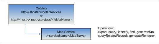
| Parent Resource | Catalog |
| Child Resources | Map Tile Layer / Table Dynamic Layer / Table Legend All Layers / Tables KML Image Map Service Extension WMTS Info |
| Required Capability | Map |
Description
Map services offer access to map and layer content. Map services can either be cached or dynamic. A map service that fulfills requests with pre-created tiles from a cache instead of dynamically rendering part of the map is called a cached map service. A dynamic map service requires the server to render the map each time a request comes in. Map services using a tile cache can significantly improve performance while delivering maps, while dynamic map services offer more flexibility. Map services should always be published as pooled services.
The REST API map service resource represents a map service. This resource works only with the default data frame of your published map document. This resource provides basic information about the map, including the layers that it contains, whether the map is cached or not, its spatial reference, initial and full extents, map units, and copyright text. It also provides some metadata associated with the service such as its service description, its author, and keywords. If the map is cached, then additional information about its tiling scheme such as the origin of the cached tiles, the levels of detail, and tile size is included. Note that multi-layer caches are only accessible in REST via export, and these requests are treated as a dynamic map service. Tile access is not supported in REST for multi-layer caches.
The map service resource supports several operations:
- Export map - Used to export a map image from a dynamic map service. The resulting map can be used for display and be in a different projection from the original data source. When generating a map image, map services are not able to change feature rendering for an existing layer, add a dynamic layer, or change the layer draw order.
- Identify - Returns information about features in one or more layers based on where a user clicks on the map.
- Find - Returns information about features in one or more fields in one or more layers based on a key word.
- Generate KML - Generates a KML document wrapped in a kmz file. The document contains a network link to the KML service endpoint with specified properties and parameters. This operation is valid on services that have not been restricted by using a token service.
- Query on a Layer / Table - Returns a subset of features in a layer or records in a table based on query criteria.
Map services do not expose editing capabilities. They provide read-only access to feature and attribute content.
New in 10.1 SP1
- Query operations on layer and dynamic layer support a new parameter called
returnDistinctValuesthat accepts a boolean value. When true query result would contain distinct values based on the fields specified inoutFieldsparameter. - Query operations on layer and dynamic layer support
geometryparameter to be used in conjunction withoutStatisticsparameter. - Legend resource returns height and width of legend symbol.
- All Layers/Table, Layer, and Dynamic Layer resources now include
ownershipBasedAccessControlForFeaturesflag to indicate the ownernship access control configuration.
New in 10.1
-
Map Service resource supports a new parameter -
returnUpdatesthat accepts a boolean value. Pass this parameter to retrieve updated information from the map service. - Map Service resource has new input parameters
optionandoutSRto support viewing of a map service footprint in arcgis.com. - Support for dynamic layers has been added to map service. This allows per request modification of renderer, joins, geodatabase version or layer order for existing map service layers. If the map service has registered workspaces, dynamic layers also allow per request addition of layers based on the data from the registered workspaces. Use
supportsDynamicLayersproperty on the map service resource to determine if the service supports dynamic layers. - Map Service resource contains
maxRecordCount,maxImageHeight, andmaxImageWidthproperties.maxRecordCountrepresents the maximum number of records that can be returned by query, find, and identify operations.maxImageHeightandmaxImageWidthrepresent the maximum image height and width, in pixels, the Map Service will export. - Map Service resource includes
tileServersproperty that advertises multiple sub domains on a map service endpoint. This allows tile requests to be split across the tile servers specified in this property, e.g. http://maps1.myserver.com and http://maps2.myserver.com. - Map Service resource includes
supportedQueryFormats. This value indicates the supported output formats for a query operation. - Map Service resource includes these new properties under
timeInfo-timeRelation,defaultTimeInterval,defaultTimeIntervalUnits,defaultTimeWindow, andhasLiveData.timeRelationindicates how the start and end time of the time slider extent are processed -esriTimeRelationOverlapswhen start and end time of the time slider are included,esriTimeRelationOverlapsStartWithinEndwhen start time is included and end time is excluded, andesriTimeRelationAfterStartOverlapsEndwhen start time is excluded and end time is included.defaultTimeIntervalanddefaultTimeIntervalUnitsindicate the initial time slider step size.defaultTimeWindowindicates the time slider window size.hasLiveDatareturns a boolean value. If true, export and identify operations will default the value fortimeparameter to be [<current server time -defaultTimeWindow>, <current server time>].
- Map Service resource includes
minScaleandmaxScaleproperties. For a cached map service these values represent the minimum and maximum map scales at which the administrator has allowed the tiles to be built. In case of a dynamic map service these values are calculated as a union of minimum and maximum scales of all the map layers. - Map Service resource includes
hasVersionedData, if any of the map layers data is versioned. When true, map service operations acceptgdbVersionparameter to switch geodatabase version.
New in 10.0
- From 10 onward, in addition to layers, map services could also publish standalone tables. The response includes a new
tablesproperty that contains some basic information about tables. The child layer resource is now a Layer / Table resource in that it represents either a layer or a table depending on the ID that was specified. - Support for time-aware map services was added at 10. If the map supports quering and exporting maps based on time, the response will include a
timeInfoproperty which includes information such as the map's time extent and the map's native time reference. However, note that the REST API always encodes time in UTC (milliseconds from epoch).
New in 10.0 SP1
- Support for a Map Service Legend child resource was added.
- Map Service resource includes scale information (minScale and maxScale) for layers.
Resource Hierarchy
Parameters
| Parameter | Details |
|---|---|
| f | Description: The
response format. The default response format is html. Values: html | json | kmz | lyr | nmf | jsapi | ve | gmaps |
| returnUpdates |
//This option was added at 10.1 Description: If value is true then returns updated time extent. If the service is not time-aware then returns an empty response. Values: true | false |
| option |
//This parameter was added at 10.1 Description: If option is footprints the footprint of the map service is returned as a feature collection. This feature collection can be viewed in a arcgis.com map. This is supported when f=json only.Value: footprints |
| outSR |
//This parameter was added at 10.1 Description: The spatial reference of the geometry returned in footprints. This parameter is supported only when option=footprints is specified.
The spatial reference should be specified as a well-known ID. If outSR
is not specified, the geometry is returned in GCS_WGS_1984. |
Example Usage
Example 1: URL for the "ESRI_StateCityHighway_USA" map service on sampleserver1.
http://sampleserver1.arcgisonline.com/ArcGIS/rest/services/Specialty/ESRI_StateCityHighway_USA/MapServerJSON Response Syntax
Note:
The following properties were added to the JSON response at 10.1
The following property was added to the JSON response at 9.3.1
supportsDynamicLayerstimeInfo -
timeRelationdefaultTimeIntervaldefaultTimeIntervalUnitsdefaultTimeWindowhasLiveDatamaxRecordCountmaxImageHeightmaxImageWidthminScalemaxScaletileServerssupportedQueryFormats
supportedImageFormatTypes
{
"currentVersion": <currentVersion>, //Added at 10.0 SP1
"serviceDescription" : "<serviceDescription>",
"mapName" : "<mapName>"
"description": "<description>",
"copyrightText" : "<copyrightText>",
"supportsDynamicLayers" : <true|false>, //Added at 10.1
"layers": [ //the spatial layers published by this service
    {
    "id" : <layerId1>,
    "name" : "<layerName1>",
    "defaultVisibility" : <true|false>,
    "parentLayerId" : <parentLayerId1>,
    "subLayerIds" : [<subLayerId11>, <subLayerId12>]
    "minScale": <minScale1>, //Added at 10.0 SP1
    "maxScale": <maxScale1>
    },
    {
    "id" : <layerId2>,
    "name" : "<layerName2>",
    "defaultVisibility" : <true|false>,
    "parentLayerId" : <parentLayerId2>,
    "subLayerIds" : [<subLayerId21>, <subLayerId22>]
    "minScale": <minScale1>,
    "maxScale": <maxScale1>
    }
],
"tables": [ //the tables published by this service - from 10 onward
    {
    "id" : <tableId1>,
    "name" : "<tableName1>"
    },
    {
    "id" : <tableId2>,
    "name" : "<tableName2>"
    }
],
"spatialReference" : {<spatialReference>},
"singleFusedMapCache" : <true | false>,
"tileInfo": {
    "rows" : <rows>, "cols" : <cols>, "dpi" : <dpi>, "format" : <format>, "compressionQuality" : <quality>,
    "origin" : {<point>},
    "spatialReference" : {<spatialReference>},
    "lods": [
        {"level" : <level1>, "resolution" : <resolution1>, "scale" : <scale1> },
        {"level" : <level2>, "resolution" : <resolution2>, "scale" : <scale2> }
    ]
},
"initialExtent" : {<envelope>},
"fullExtent" : {<envelope>},
//from 10 onward - if the map supports querying and exporting maps based on time
"timeInfo" : {
  "timeExtent": [<startTime>, <endTime>],
  "timeReference": {
    "timeZone": "<timeZone>",
    "respectsDaylightSaving": <true | false>
  },
  "timeRelation": "<esriTimeRelationOverlaps | esriTimeRelationOverlapsStartWithinEnd | esriTimeRelationAfterStartOverlapsEnd>",
  "defaultTimeInterval" : <time interval>,
  "defaultTimeIntervalUnits" : "<time interval units>",
  "defaultTimeInterval" : <time interval>,
  "defaultTimeWindow" : <time window>,
  "hasLiveData" : <true | false>,
},
"units" : "<units>",
"supportedImageFormatTypes" : "<supportedImageFormatTypes>",
"documentInfo": {
    "<key1>" : "<value1>",
    "<key2>" : "<value2>"
},
//comma separated list of supported capabilities - e.g. "Map,Query,Data"
"capabilities" : "<capabilities>",
"maxRecordCount" : <maxRecordCount>, //Added at 10.1
"maxImageHeight" : <maxImageHeight>, //Added at 10.1
"maxImageWidth" : <maxImageWidth>, //Added at 10.1
"minScale" : <minimum map scale>, //Added at 10.1
"maxScale" : <maximum map scale>, //Added at 10.1
"tileServers" : ["<tileServerUrl1>","<tileServerUrl2>","<tileServerUrl2>"], //Added at 10.1
"supportedQueryFormats" : "<query output formats>"
}
JSON Response Example
{
    "currentVersion": 10.1,
    "serviceDescription": "Test Map Service Description",
    "mapName": "Street Map Pro Data",
    "description": "Street Map USA",
    "copyrightText": "ESRI",
    "supportsDynamicLayers": false,
    "layers": [
        {
            "id": 0,
            "name": "Cities",
            "defaultVisibility": true,
            "parentLayerId": -1,
            "subLayerIds": null,
            "minScale": 0,
            "maxScale": 0
        },
        {
            "id": 1,
            "name": "States",
            "defaultVisibility": true,
            "parentLayerId": -1,
            "subLayerIds": null,
            "minScale": 0,
            "maxScale": 0
        },
        {
            "id": 2,
            "name": "Counties",
            "defaultVisibility": false,
            "parentLayerId": -1,
            "subLayerIds": [
                3,
                4
            ],
            "minScale": 0,
            "maxScale": 0
        },
        {
            "id": 3,
            "name": "Large Counties",
            "defaultVisibility": false,
            "parentLayerId": 2,
            "subLayerIds": null,
            "minScale": 0,
            "maxScale": 0
        },
        {
            "id": 4,
            "name": "Small Counties",
            "defaultVisibility": false,
            "parentLayerId": 2,
            "subLayerIds": null,
            "minScale": 0,
            "maxScale": 0
        }
    ],
    "spatialReference": {
        "wkid": 4326
    },
    "singleFusedMapCache": true,
    "tileInfo": {
        "rows": 512,
        "cols": 512,
        "dpi": 96,
        "format": "JPEG",
        "compressionQuality": 75,
        "origin": {
            "x": -130,
            "y": 50
        },
        "spatialReference": {
            "wkid": 4326
        },
        "lods": [
            {
                "level": 0,
                "resolution": 8.46,
                "scale": 32000
            },
            {
                "level": 1,
                "resolution": 4.23,
                "scale": 16000
            },
            {
                "level": 2,
                "resolution": 2.11,
                "scale": 8000
            },
            {
                "level": 3,
                "resolution": 1.05,
                "scale": 4000
            },
            {
                "level": 4,
                "resolution": 0.52,
                "scale": 2000
            }
        ]
    },
    "initialExtent": {
        "xmin": -109.55,
        "ymin": 25.76,
        "xmax": -86.39,
        "ymax": 49.94,
        "spatialReference": {
            "wkid": 4326
        }
    },
    "fullExtent": {
        "xmin": -130,
        "ymin": 24,
        "xmax": -65,
        "ymax": 50,
        "spatialReference": {
            "wkid": 4326
        }
    },
    "units": "esriDecimalDegrees",
    "supportedImageFormatTypes": "PNG32,PNG24,PNG,JPG,DIB,TIFF,EMF,PS,PDF,GIF,SVG,SVGZ",
    "documentInfo": {
        "Title": "StreetMap USA.mxd",
        "Author": "ESRI Data Team",
        "Comments": "ESRI Data and Maps 2004",
        "Subject": "Street level data for the US",
        "Category": "vector",
        "Keywords": "StreetMap USA"
    },
    "capabilities": "Map,Query,Data",
    "maxRecordCount": 1000,
    "maxImageHeight": 2048,
    "maxImageWidth": 2048,
    "minScale": 0,
    "maxScale": 0,
    "tileServers": ["http://myserver/arcgis/rest/services/basemap/MapServer","http://myserver2/arcgis/rest/services/basemap/MapServer"],
    "supportedQueryFormats": "JSON, AMF"
}
Example 2: When requesting updated information from the service:
JSON Response Syntax
{
  "timeExtent":
    [
      startTime, endTime
    ]
}
JSON Response Example
{
  "timeExtent":
    [
      1230768000000, 1243814400000
    ]
}
Example 3: When requesting footprint for a service:
URL: http://sampleserver.arcgisonline.com/arcgis/rest/services/Specialty/ESRI_StateCityHighway_USA/MapServer?f=json&option=footprints&outSR=102100
JSON Response Syntax
{
"featureCollection": {
"layers": [
{
"layerDefinition": {
"type": "Feature Layer",
"geometryType": "esriGeometryPoint",
"extent": {
<envelope>
},
"objectIdField": "id",
"displayFieldName": "<displayFieldName>",
"drawingInfo": {
"renderer": {
"type": "simple",
"label": "<label>",
"description": "",
"symbol": {
"height": 24,
"xoffset": 0,
"yoffset": 0,
"width": 24,
"contentType": "image/png",
"type": "esriPMS",
"imageData": "<imageData>",
"url": "<imageUrl>"
}
}
},
"fields": [
{
"name": "id",
"alias": "ID",
"type": "esriFieldTypeOID"
},
{
"name": "title",
"alias": "Title",
"type": "esriFieldTypeString"
},
{
"name": "summary",
"alias": "Summary",
"type": "esriFieldTypeString"
},
{
"name": "description",
"alias": "Description",
"type": "esriFieldTypeString"
},
{
"name": "tags",
"alias": "Tags",
"type": "esriFieldTypeString"
},
{
"name": "type",
"alias": "Type",
"type": "esriFieldTypeString"
},
{
"name": "thumbnail",
"alias": "Thumbnail",
"type": "esriFieldTypeString"
},
{
"name": "xmin",
"alias": "xmin",
"type": "esriFieldTypeDouble"
},
{
"name": "ymin",
"alias": "ymin",
"type": "esriFieldTypeDouble"
},
{
"name": "xmax",
"alias": "xmax",
"type": "esriFieldTypeDouble"
},
{
"name": "ymax",
"alias": "ymax",
"type": "esriFieldTypeDouble"
},
{
"name": "accessInformation",
"alias": "Access Information",
"type": "esriFieldTypeString"
},
{
"name": "licenseInfo",
"alias": "License Information",
"type": "esriFieldTypeString"
},
{
"name": "credits",
"alias": "Credits",
"type": "esriFieldTypeString"
},
{
"name": "link",
"alias": "Link",
"type": "esriFieldTypeString"
},
{
"name": "arcgisJslink",
"alias": "ArcgisJsLink",
"type": "esriFieldTypeString"
}
]
},
"featureSet": {
"geometryType": "esriGeometryPoint",
"spatialReference": {
"wkid": <wkid>
},
"features": [
{
"geometry": {
<point>
},
"attributes": {
"id": 1,
"title": "<title>",
"summary": "<summary>",
"description": "<description>",
"tags": "[\"<tag1>\,\"<tag2>\"]",
"type": "MapServer",
"thumbnail": "<thumbnailUrl>",
"xmin": <xmin>,
"ymin": <ymin>,
"xmax": <xmax>,
"ymax": <ymax>,
"accessInformation": "<accessInformation>",
"licenseInfo": "<licenseInfo>",
"credits": "<credits>",
"link": "<serviceResourceLink>",
"arcgisJslink": "<View in JSAPI Link>"
}
}
]
},
"popupInfo": {
"title": "{title} ({type})",
"fieldInfos": [
{
"fieldName": "id",
"label": "ID",
"visible": false
},
{
"fieldName": "title",
"label": "Title",
"visible": true
},
{
"fieldName": "summary",
"label": "Summary",
"visible": true
},
{
"fieldName": "description",
"label": "Description",
"visible": true
},
{
"fieldName": "tags",
"label": "Tags",
"visible": true
},
{
"fieldName": "type",
"label": "Type",
"visible": true
},
{
"fieldName": "thumbnail",
"label": "Thumbnail",
"visible": false
},
{
"fieldName": "xmin",
"label": "xmin",
"format": {
"places": 2,
"digitSeparator": false
},
"visible": false
},
{
"fieldName": "ymin",
"label": "ymin",
"format": {
"places": 2,
"digitSeparator": false
},
"visible": false
},
{
"fieldName": "xmax",
"label": "xmax",
"format": {
"places": 2,
"digitSeparator": false
},
"visible": false
},
{
"fieldName": "ymax",
"label": "ymax",
"format": {
"places": 2,
"digitSeparator": false
},
"visible": false
},
{
"fieldName": "accessInformation",
"label": "Access Information",
"visible": true
},
{
"fieldName": "licenseInfo",
"label": "License Information",
"visible": true
},
{
"fieldName": "credits",
"label": "Credits",
"visible": true
},
{
"fieldName": "link",
"label": "Link",
"visible": true
}
],
"description": null,
"showAttachments": false,
"mediaInfos": [
{
"type": "image",
"caption": "Initial Extent: [{xmin}, {ymin}] - [{xmax}, {ymax}]",
"value": {
"sourceURL": "{thumbnail}",
"linkURL": "{arcgisJslink}"
}
}
]
}
}
]
}
}
JSON Response Example
{
"featureCollection":{
"layers":[{
"layerDefinition":{
"type":"Feature Layer",
"geometryType":"esriGeometryPoint",
"extent":{"xmin":-4254455.8606807785,"ymin":-1273247.593581636,"xmax":-3967497.083911836,"ymax":-1127922.6881048125,"spatialReference":{"wkid":102100}},
"objectIdField":"id",
"displayFieldName":"Maps/BrazilMapServer",
"drawingInfo":{
"renderer":{
"type":"simple",
"label":"Maps/Brazil",
"description":"",
"symbol":{
"height":24,
"xoffset":0,
"yoffset":0,
"width":24,
"contentType":"image/png",
"type":"esriPMS",
"imageData":"iVBORw0KGgoAAAANSUhEUgAAADQAAAA0CAYAAADFeBvrAAAABGdBTUEAALGPC/xhBQAAAAlwSFlzAAAOwQAADsEBuJFr7QAAABl0RVh0U29mdHdhcmUAUGFpbnQuTkVUIHYzLjUuMU7nOPkAAA01SURBVGhD7Vn5c1X1HRVbRRMSo8QEAgmBSEIWkpCQkJCE7CRk3wMvhJAAMRuEJC/7BoEoQRbLowpURBChoYKgKGhV2mlrK3UXrWLFpT84/QPq2HHs6Tk373ZSp+1ojS90ppk5c+97ue/dz/me8znf7/e+G274/99/PwJ5rTtvK+1/2Hf18MnIsv4DYeWDh3yGXvhsyn//jZP0yYIW25Kirgf7V209eq68//ArlqGjVyxDx98o6T34fEH7Pltx9wOZk1Tat7ttYcveiJyWvefX7bmANTtPoWbPWVTfd844rtt7HuWDx1Hc8xMU9RxAftueyzmbRvK/3R0ceHVxz8GynJbdn6+//1k0PfRr1B+8hI0P/wrNR36H5kd+h5ZHX+b5K6g/8Dwqd4yicvgMyvuPIrtpx4gDy/xmtyrrPxyRVNXxl/qDv8TGI79B64lX0f3E++h8/B10/OwttPF128nX0PrY77H52Eto1vH4qyR4GRXbRqnYQds3u5ODrkqrGXiqYvgkOk+/x4J/i77zH6Dn3FV0kFD32ffQcfoKus68i45TV9B89CW0jb4O6+hbVO0VtB5/BeUDh2nHw+sdVO5/vk1+24+C48vbv9x05GUMXPgY/ec/xODFT8YIkUT7qbfQRUJSrO3EG8RrJEeSP7tinDcffRl3//g55G3eebVh5HnnSSeVu2mkYnH2emxirww++6lByjz2nL2K3qc+MNDNcynWTmWso29TzXcN0p2n36EV30D2xhGU9R7ImnRCWY3b+wPjc1Fre84g0v/0NQMi1n3uffSyaBUu6/U+yaNxfhUDT39kXNd3/hqv+Yipt5+kdrRNOqF8696dswJjUNJ72CDU++QHVOIKSbw/VuxTHxoE+njsk1pPfkgyH/N4DT1PXKU9P6Ud30NKdT/Sarr7J51Qad+BDu/gaATGl7AwjvyFT9kfY9bqOvMHdLKPVLChEl+rd3SuPuonSQ3Cxod+gfiVzUit6W6ddEIVw8cSIrPXwHm6D5at7sIgrTZw4RPDakZcP0aceIsE3zDivPnoZaNnOknO6LVnriG50orF2WuRvXlHzqQTUgEZtYOX/KPScaurO+Ism9FLq40Vy/hWGJx61yBl/SmJKfWojmHPc9eQ17IP3sGxstufspq2uV4XhCxDjy5JtLR+HppahmnuPghKLMKae08Z844KN8Be+cc5X6/f9wzCllfBfU4EYosbwHBpui7ImEWUdO9fl7jaioiMSszwC4WLxxzMW5iI2KI65LXthWXoBEp7DyGzbjvC0yxw9pgHT14XW1LHQGh/5Lohs2bkpHPF9uPFlfecOJPXshMJqzYiOq8aIUn5CIrNwPzIRPgwNHyDE+A5bxHcfYMxZ2EsonPXYpmlmdhsS66y3nhdELIMHVnDUX+7YugxWLYdZz/spAKDYE8hcXUbkle3In/z2HvLVjUhhQqm1vQh4+5B5Lfc90W+dVf6dUGEG7WbS3oeOFLSewAbbNoqnAX3OJwYh43iU6o6kLK2k8T6kdO0zSCV3TjMPhkGtwzEDhR27PvSsu3Y5PdN/YPP3lRgtV3MatrJPc7TqOU6rHzwYapznxrbIJRW3Yn09d3I2NBHJXaS1Hb+b5vWa8hpHkFmwxCKuvYj32oDV+qPVe85fcukKVXa8+BPkqt62OQnudx5gUuWfSiw3m8QMQjRTuk13Xw9gBX1gyhoGUFe8w5k1m/Rps4gnt10L893Y/XwKAra94vUiUkhZNlyrGJ57Rak1Azg7gdeRAl3nypwBUc/taYLuZtHkNWwFWlVVpLqos22oti6B4WEyMpuuVRpRf0Qz3fBsvVRVN7zOMnZsGZktN2hpPRwI69l12/jSjchv+MAmo9d5mTYPxYE9VvZ9M2GSlIio3ZgrH9IlHH+j94yFCTh5DVWDsIwd6yHUb3nKZT2H5H9vmh66JK3w0gx0QIy67Z8sShrHdbuetrYVi/KrMByFq++iGIMx6/caCRcNolkNQyyd6hQ1z5abCwscqggIxpRjPXldVv4fOGQYbs1O04jo24bKrY/OuAwQsWdtpLU6i7O7tV8LnCJO83L8ItMQkRmpaFQeMYqhKaXGXGdxabPbhqi1XahtOcBRTTyW3cbpMLTyw1CHBzk8v3Ke05xg/cC0tZvYT/ZLjmMUGG7rTGBtgpJLkPt/gvGQ4+54YmYGbCYk2iREQSxxbVUbZVhKRVf2mPDqsFDyGZMpzD5wjNWclWeY/SbMTdx3VfB+at611kkWNqQvmHwzw4lFFfWSEIl9PxhhsJzCE0tgcsdXnCfvQD+0ekGkcSKVsSVNyKutB6JLJiLThKtQ2haOd8z1mx8hnCI17VRrZVYOzKKmr0XEFPciOS1HY4jlNe6uzQ6vwb+MZmcNLtQvfsMG3vIWI+5unvDmcSmz74LvouWUYkylLbfi+rth4yekbLc6/BzHQbpJYUbcFdUGpdIa6n2RRR2HURMEQlVWa85TKHidlsYCf3Na0GkYZtsBkHlvSeNAt19/OHs5gnn22fCZbqIBSKhcBXyG3sQXVSPoKSVmBe5Aj4hyzBrwWLMnB9JLOJc9ggaDv0CS4qbsTinBssqrO86jJBuxBF+3SckBp7zIxDMLQK33/T/40yoQRYbQzKz4eI+G26ecwk/eMwJhW9YMrwCYzHdJ5BE/Ul+AWbcFWr02vq9F/nZEQTEF2BJQS3iy5vedCghjmitAsBjbjDu8ApgKCRhGXebBe33I4lK+UUmY7q3Pwv3Y18F4PaZOl+A22lFQYQ854ciIDaTfcZ5q37ECJmghFyjv1Y0bh91KCFOrjdm1A1cmMstgazl5ObBozeVCIbf4hQWlsdwyIBPaKxhLe+gGCoXz+1DrIF57C+/RUnwi0hDSMoqhKVbaN88Y7uhXtt45CWHrb7Nn0Cm6CeR9PV9H3kHx+BW9s2trh6Y6jQdU53d4XqnD9ULMfY9Xv6RJMR9UGgCZvPo5R9lYAYV8vQLw5xFKfCNSEEg1YnKrtLT06OOUkdkBG3CfkD8sLDz/gVpNT1v+tM6rtxy61mC020ecHIdCwYnN4bDHbMZFF5GrEtNl+lz4HLnXFoyGB6+YQyFKCZdOh+OVKGow/bipiO/cnEEoX8iwhveTGip7xScWDaLs/1DMYxg37ClcPX0gdsMXz79mYmp0zxwi9sMuHsHURElWgR3qiHso0A+Q1iIGf4RCFiahbiSBu6jbKcaDv7c7fskYyqio6EIMZW4lZhG6MnM7YQ74bG0pH4lZ/6LccX1CONEG5acjejMAoQnZmF+dCrmRaTCK4h9tDAZflGpCGE6xpUpAIb+yC1EnV15857fC6/xqtxkV0REbiOmE56EF+FDzCPuIub7hkSv4ERpy7y7//PKocOw9Nm+ym7Y8nlKpfWruLImJFVa/5rTdM+nXPI8SWVrA+OzPOyKa8A0cN/LT5VfJyNV5O077ERm8zhXBIggYiERTkQQkUSGv3/wB4kpaddKSy1PBAUE5cXExFjWWiotZUVluT4+PvrMTPvASGknQupr4L4XUmbjm8qIjFRREb6EPxFCLCKiiVginlhGJHI0tscsiUHc0jgE+QcN2v+v60RY5BcQUnUWcSfhRugnFJGSUrr/hCllqjPeZlLGJKNiwu1ERCKZSCMyCP0IvOLGKTeen+bsgtmz5vzNaarTBr6Xar9O1y+xD4RU8iOktkiZSilwpNKEkBpvNX2xrKDRU7+oV6RMmL0oqSEiIqFn0XmEfvxdOeWGKR+5THNBWFjYZ/b39f8VhCbMJGIpIbVESkqpFzVo6lHTehNKyEw03UA30g01msHEYiLBTkZF5hIFRBFRQlQSn7i6uCIkZOFrPC8mCu3EsnlcbicVw2M4oUHSYCkcvq7Sd7adGdHje0exLFsoAEIJ9YLUUWEqUKqYZEp5Xkb0EvuIDkLvjSelQZAFZT8FSCDhS8wgNA2ol0zbfacYNz8s/4qQkk0jJn//O0L66VBWkwIqWsULVjuZ8m9ASLZTYqpHTUITFg6mQhohk5AUUhrJcko2WS6OSCEUBFJJpArsxKRWI7HOTlKv9T9do2v1GQWJklEp+a8UmnBC4y2nHpIdfAklnEIhijATTo2uYJBaan71lJSRYiKh1yIiq8mmIqMB0XcowmVlPbZSD2nSVhBNqOWULmYoyM9uhGwnlZRIGlGTlNJKAZFEqC+UeipakBKCzvW+iKj39BmprH7UAPkSspsGTvOdnDEhE6zZQyYh03a6ibytETRXCAE8NydWFae5RYVKNREUVLygcymiVJMqspk+q3RT7yhBZWtTnQm12/hgMFWSBcaTUgFzCPWUiJlLH6mmYs3lj4gqxfRa70sRxb4+o88qqk0ybjzXFKEV/Hh1JiS2v76O04iZpHRjjaYmWllQRWmUVaB6QcXKRrKlCb2WGlq86lqTiL5DyykpY5KRK8Yvfb4zIX6fsYYySenLNWLjtw0qQH43icn/Iic7qrlVsBQUdC7ofamhcJF1RcSNkPIaLFOZCScjQv+Tf38HMj5k7OWK5X8AAAAASUVORK5CYII=",
"url":"http://sampleserver/arcgis/rest/static/images/BlueShinyPin.png"
}
}
},
"fields": [
{
"name": "id",
"alias": "ID",
"type": "esriFieldTypeOID"
},
{
"name": "title",
"alias": "Title",
"type": "esriFieldTypeString"
},
{
"name": "summary",
"alias": "Summary",
"type": "esriFieldTypeString"
},
{
"name": "description",
"alias": "Description",
"type": "esriFieldTypeString"
},
{
"name": "tags",
"alias": "Tags",
"type": "esriFieldTypeString"
},
{
"name": "type",
"alias": "Type",
"type": "esriFieldTypeString"
},
{
"name": "thumbnail",
"alias": "Thumbnail",
"type": "esriFieldTypeString"
},
{
"name": "xmin",
"alias": "xmin",
"type": "esriFieldTypeDouble"
},
{
"name": "ymin",
"alias": "ymin",
"type": "esriFieldTypeDouble"
},
{
"name": "xmax",
"alias": "xmax",
"type": "esriFieldTypeDouble"
},
{
"name": "ymax",
"alias": "ymax",
"type": "esriFieldTypeDouble"
},
{
"name": "accessInformation",
"alias": "Access Information",
"type": "esriFieldTypeString"
},
{
"name": "licenseInfo",
"alias": "License Information",
"type": "esriFieldTypeString"
},
{
"name": "credits",
"alias": "Credits",
"type": "esriFieldTypeString"
},
{
"name": "link",
"alias": "Link",
"type": "esriFieldTypeString"
},
{
"name": "arcgisJslink",
"alias": "ArcgisJsLink",
"type": "esriFieldTypeString"
}
]
},
"featureSet":{
"geometryType":"esriGeometryPoint",
"spatialReference":{
"wkid":102100
},
"features":[{
"geometry":{
"x":-4110976.4722963073,
"y":-1200585.1408432242
},
"attributes":{
"id": 1,
"title": "Maps/Brazil",
"summary": "",
"description": "",
"tags": "[\"Brazil\"]",
"type": "MapServer",
"thumbnail": "http://sampleserver/arcgis/rest/services/Maps/Brazil/MapServer/info/thumbnail",
"xmin": -4254455.8606807785,
"ymin": -1273247.593581636,
"xmax": -3967497.083911836,
"ymax": -1127922.6881048125,
"accessInformation": "",
"licenseInfo": "",
"credits": "",
"link": "http://sampleserver/arcgis/rest/services/Maps/Brazil/MapServer",
"arcgisJslink": "http://sampleserver/arcgis/rest/services/Maps/Brazil/MapServer?f=jsapi"
}
}
]
},
"popupInfo":{
"title": "{title} ({type})",
"fieldInfos": [
{
"fieldName": "id",
"label": "ID",
"visible": false
},
{
"fieldName": "title",
"label": "Title",
"visible": true
},
{
"fieldName": "summary",
"label": "Summary",
"visible": true
},
{
"fieldName": "description",
"label": "Description",
"visible": true
},
{
"fieldName": "tags",
"label": "Tags",
"visible": true
},
{
"fieldName": "type",
"label": "Type",
"visible": true
},
{
"fieldName": "thumbnail",
"label": "Thumbnail",
"visible": false
},
{
"fieldName": "xmin",
"label": "xmin",
"format": {
"places": 2,
"digitSeparator": false
},
"visible": false
},
{
"fieldName": "ymin",
"label": "ymin",
"format": {
"places": 2,
"digitSeparator": false
},
"visible": false
},
{
"fieldName": "xmax",
"label": "xmax",
"format": {
"places": 2,
"digitSeparator": false
},
"visible": false
},
{
"fieldName": "ymax",
"label": "ymax",
"format": {
"places": 2,
"digitSeparator": false
},
"visible": false
},
{
"fieldName": "accessInformation",
"label": "Access Information",
"visible": true
},
{
"fieldName": "licenseInfo",
"label": "License Information",
"visible": true
},
{
"fieldName": "credits",
"label": "Credits",
"visible": true
},
{
"fieldName": "link",
"label": "Link",
"visible": true
}
],
"description": null,
"showAttachments": false,
"mediaInfos": [
{
"type": "image",
"caption": "Initial Extent: [{xmin}, {ymin}] - [{xmax}, {ymax}]",
"value": {
"sourceURL": "{thumbnail}",
"linkURL": "{arcgisJslink}"
}
}
]
}
}
]
}
}