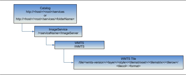
| URL | http://<wmts-url>/tile/<wmts-version>/<layer>/<style>/<tilematrixset>/<tilematrix>/<tilerow>/<tilecol>.<format> |
|---|---|
| KVP URL | http://<wmts-url>?service=wmts&request=getTile&version=<wmts-version>&layer=<layer>&style=<style>&tilematrixset=<tilematrixset>&tilematrix=<tilematrix>&tilerow=<tilerow>&tilecol=<tilecol>&format=<format> |
| Parent Resource | WMTS |
| Required Capability | Image |
Description
This resource is supported from 10.1 onwards.
The WMTS Tile resource represents a single cached tile,
which is a fragment of an image in the context of WMTS specification. Users can request the WMTS tiles in both RESTful and Key-Value Pair (KVP) syntax as defined by OGC WMTS specification.
Resource Hierarchy
URL Tokens
| URL Token | Details |
|---|---|
| layer | Required
Description: Layer identifier Values: valid layer identifier advertised in WMTS service metadata (GetCapabilities response) Example: layer=0
|
| style | Optional *Note: since ArcGIS Server WMTS will always have only one style, so client can omit this parameter or code it as "default"
Description: Style identifier Values: valid style identifier advertised in WMTS service metadata (GetCapabilities response) Example: style=default
|
| tilematrixset | Required
Description: TileMatrixSet identifier, "TileMatrixSet" is a concept in OGC WMTS specification which is similar to Tiling Schema Values: the identifier of one of the TileMatrixSet advertised in WMTS service metadata (GetCapabilities response), which includes well-known TileMatrixSet like Google Maps/ArcGIS Online, or a customized TileMatrixSet defined by service publisher. Example: tileMarixSet=google_maps
|
| tilematrix | Required
Description: TileMatrix identifier Values: the identifier of one of the TileMatrix defined in a particular TileMatrixSet Example: tileMarix=tileMatrix0
|
| tilerow | Required
Description: Row index of a tile matrix Example: tilerow=0
|
| tilecol | Required
Description: Column index of a tile matrix Example: tilecol=0
|
| format | Optional *Note: it is mandatory according to spec, but let's make it optional such that if omitted server picks up the best fit
Description: Output format of the tile Values: the suffix of one of the supported formats advertised in WMTS service metadata (GetCapabilities response), usually png, jpeg, or ??jpegpng?? Example: format=png
|
Example Usage
Example 1:
http://sampleserver6.arcgisonline.com/arcgis/rest/services/WorldTimeZones/ImageServer/WMTS/tile/1.0.0/WorldTimeZones/default/default028mm/1/0/0.pngExample 2:
http://sampleserver6.arcgisonline.com/arcgis/rest/services/WorldTimeZones/ImageServer/WMTS?service=WMTS&version=1.0.0&request=gettile&layer=WorldTimeZones&style=default&tileMatrixSet=default028mm&tileMatrix=1&TileRow=0&TileCol=0&format=image/png