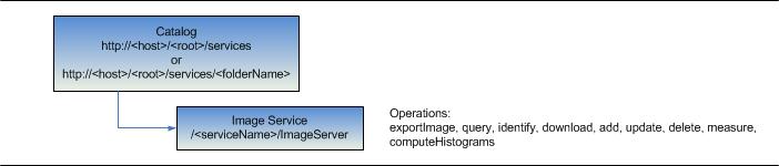
| URL | http://<catalog-url>/<serviceName>/ImageServer |
|---|---|
| Supported Operations | Export Image Query Download Identify Add Rasters Update Rasters Delete Rasters Measure Compute Histograms Uploads |
| Parent Resource | Catalog |
| Child Resources | KML Image Raster Catalog Item Raster File Image Tile Key Properties Raster Attribute Table Colormap Histograms Info |
Description
An image service provides access to raster data through a web service. Multiple rasters can be served as one image service through mosaic dataset technology, dynamically processed and mosaicked on the fly. An image service supports accessing both the mosaicked image and its catalog, as well as individual raster in the mosaic.
An image service supports dynamic access and tiled access. Dynamic access provides much more functionalities and tiled access provides faster access to pre-rendered pictures.
The map service resource supports the following operations
Basic raster information including its spatial reference, extent, pixel size, pixel type, number of bands, and band statistics, thumbnail, key properties, and metadata can be access for the entire mosaic as well as individual rasters (through Raster Catalog Item).
The REST API image service resource represents an image service published with ArcGIS Server. The resource provides basic information associated with the image service such as the service description, its name, description, extent, pixel sizes, and band counts.
From 10 onwards, this resource also returns the accessible fields, timeInfo of the image service.
option and outSR to support viewing of a Image service footprint in arcgis.com.From 10.1 onwards, this resource also includes the following:
initialExtent, fullExtent, singleFusedMapCache, tileInfo properties that indicate cache information of the service.
defaultMosaicMethod, mosaicOperator, defaultCompressionQuality, defaultResamplingMethod properties that indicates service defaults. The default mosaic rule is composed of defaultMosaicMethod and mosaicOperator. When defaultMosaicMethod is esriMosaicAttribute, image service uses sortField and sortValue along with it.
allowRasterFunction, allowedMosaicMethods, maxRecordCount, maxImageHeight, maxImageWidth, maxDownloadImageCount,maxDownloadSizeLimit, maxMosaicImageCount properties that indicates service contraints.
rasterFunctionInfos, rasterTypeInfos, mensurationCapabilities properties that indicate supported raster function templates (for exportimage), raster types (for add/update rasters), and mensuration capabilities (for mensuration).
hasHistograms, hasColormap, hasRasterAttributeTable properties that indicate if a corresponding resource is available for the service.
capabilities properties that indicates supported operations.
editFieldsInfo and ownershipBasedAccessControlForRasters containing editor tracking and access control related properties.
Resource Hierarchy
Parameters
| Parameter | Details |
|---|---|
| f | Description: The
response format. The default response format is html. Values: html | json | kmz | lyr |
| option |
//This parameter was added at 10.1 Description: If option is footprints the footprint of the image service is returned as a feature collection. This feature collection can be viewed in a arcgis.com map. This is supported when f=json only.Value: footprints |
| outSR |
//This parameter was added at 10.1 Description: The spatial reference of the geometry returned in footprints. This parameter is supported only when option=footprints is specified.
The spatial reference should be specified as a well-known ID. If outSR
is not specified, the geometry is returned in GCS_WGS_1984. |
Example Usage
Example 1: URL to an Image Service.
http://sampleserver6.arcgisonline.com/arcgis/rest/services/CharlotteLAS/ImageServerJSON Response Syntax
{
"currentVersion": <currentVersion>, //Added at 10.0 SP1
"serviceDescription" : "<serviceDescription>",
"name" : "<name>",//name of the service
"description" : "<description>",
"extent" : {<extent>},//extent of the service
//New in 10.1. Initial extent of the service.
"initialExtent" : {<envelope>},
//New in 10.1. Full extent of the service.
"fullExtent" : {<envelope>},
//Added at 10.0. Optional. Time information of the service.
"timeInfo" :
{
  "startTimeField" : "<startTimeField>",//New in 10.1. The name of the attribute used as start time.
  "endTimeField" : "<endTimeField>",//New in 10.1. The name of the attribute used as end time.
  "timeExtent" : [<startTime>, <endTime>],//Added at 10.0. The time extent of the service (start/end), represented using "Epoch time": milliseconds since 1970.
  "timeReference" : null//Added at 10.0. The time reference of the service
 },
"pixelSizeX" : <pixelSizeX>,//The base pixel size in X dimension. It's usually the source resolution of single raster service; or best available raster resolution in a mosaic dataset (can be multi-resolution, multi-source).
"pixelSizeY" : <pixelSizeY>,//The base pixel size in Y dimension. It's usually the source resolution of single raster service; or best available raster resolution in a mosaic dataset (can be multi-resolution, multi-source).
"bandCount" : <bandCount>,//Number of bands of the image service.
"pixelType" : "<pixelType>",//Represents pixel type, e.g. U8 means unsigned 8bit; F32 means float 32bit; S16 means signed 16bit
"minPixelSize" : <minPixelSize>,//Minimum pixel size.
"maxPixelSize" : <maxPixelSize>,//Maxmum pixel size.
"copyrightText" : "<copyrightText>",//Copyright text.
"serviceDataType" : "<serviceDataType>",//Type of service data, can be:
"minValues" : [<minValue1>, <minValue2>],//Minimum pixel values of all bands
"maxValues" : [<maxValue1>, <maxValue2>],//Maximum pixel values of all bands
"meanValues" : [<meanValue1>, <meanValue2>],//Mean pixel values of all bands
"stdvValues" : [<stdvValue1>, <stdvValue2>],//Standard deviation of pixel values of all bands

//accessible fields - added at 10
"objectIdField" : "<objectIdFieldName>",
//domain property is added at 10.1
//editable and nullable peroperties are available only if image service has edit capability
"fields" : [
  {"name" : "<fieldName1>", "type" : "<fieldType1>", "alias" : "<fieldAlias1>", "length" : "<length1>", "editable" : "<true | false>","nullable" : "<true | false>","domain" : <domain1>},
  {"name" : "<fieldName2>", "type" : "<fieldType2>", "alias" : "<fieldAlias1>", "length" : "<length2>", "editable" : "<true | false>","nullable" : "<true | false>","domain" : <domain2>}
],
//New in 10.1. Comma separated list of supported capabilities - e.g. "Image,Metadata,Pixels,Catalog,Download,Mensuration,Edit,Uploads".
"capabilities" : "<capabilities>"
//New in 10.1. Default compression quality of jpeg format exported image (applies to jpg and jpgpng).
"defaultCompressionQuality": "<defaultCompressionQuality>",
//New in 10.1. Default resampling method.
"defaultResamplingMethod": "<defaultResamplingMethod>",
//New in 10.1. The maximum number of rows that the service allows in a client request.
"maxImageHeight": <maxImageHeight>,
//New in 10.1. The maximum number of columns that the service allows in a client request.
"maxImageWidth": <maxImageWidth>,

//New in 10.1. Optional. Default mosaic method.
"defaultMosaicMethod": "<defaultMosaicMethod>",
//New in 10.1. Optional. Comma separated list of allowed mosaic methods. Can be one or more of the following: None,Center,NorthWest,LockRaster,ByAttribute,Nadir,Viewpoint,Seamline. Prefix with "esriMosaic" to use as MosaicMethod property in MosaicRule object
"allowedMosaicMethods": "<allowedMosaicMethods>",
//New in 10.1. Optional. Specifies the sort field of default mosaic rule when byattribute is used as the default mosaic method.
"sortField": "<sortField>",
//New in 10.1. Optional. Specifies the sort base value of default mosaic rule when byattribute is used as the default mosaic method. The type depends on attribute type
"sortValue": <sortValue>,
//New in 10.1. Optional. Specifies default mosaic operator.
"mosaicOperator": "<mosaicOperator>",
//New in 10.1. Optional. The maximum records returned in a query response. For single raster based image services, the maxRecordCount is -1.
"maxRecordCount": <maxRecordCount>,
//New in 10.1. Optional. The maximum number of downloadable rasters (number of rows) that the service allows per request
"maxDownloadImageCount": <maxDownloadImageCount>,
//New in 10.1. Optional. The maximum size of download raster request that the service allows per request
"maxDownloadSizeLimit": <maxDownloadSizeLimit>,
//New in 10.1. Optional. The maximum number of rasters the service can mosaic per request
"maxMosaicImageCount": <maxMosaicImageCount>,


 //New in 10.1. Indicates the existence of tile resource
 "singleFusedMapCache" : <true | false>,
 //New in 10.1. Optional. Information of tile resource
 "tileInfo": {
    "rows" : <rows>, "cols" : <cols>, "dpi" : <dpi>, "format" : <format>, "compressionQuality" : <quality>,
    "origin" : {<point>},
    "spatialReference" : {<spatialReference>},
    "lods": [
        {"level" : <level1>, "resolution" : <resolution1>, "scale" : <scale1> },
        {"level" : <level2>, "resolution" : <resolution2>, "scale" : <scale2> }
    ]
 },
 //New in 10.1. The denominator of the minimum scale at which caching may be available. It's 0 for not cached service.
 "minScale": <minScale>,
 //New in 10.1. The denominator of the maximum scale at which caching may be available. It's 0 for not cached service.
 "maxScale": <maxScale>,

 //New in 10.1. Indicates whether the service allows raster functions in request or not
 "allowRasterFunction": [<allowRasterFunction>],
 //New in 10.1. Optional. Specifies the supported raster function templates that client can invoke. The first one is applied to exportImage request by default
 "rasterFunctionInfos":   [
 {
   "name": "<name>",
   "description": "<description>",
   "help": "<help>"
  }
 ],

 //New in 10.1. Optional. Editor tracking fields information.
"editFieldsInfo": {
   "creationDateField": "<creationDateField>",
   "creatorField": "<creatorField>",
   "editDateField": "<editDateField>",
   "editorField": "<editorField>"
   "realm":"<realm>",
   },
//New in 10.1. Optional. Ownership based access (update/delete) control information.
"ownershipBasedAccessControlForRasters": {
  "allowOthersToUpdate": <true | false>,
  "allowOthersToDelete": <true | false>
 },
//New in 10.1. Optional. Supported raster types in add rasters operation
"rasterTypeInfos": [
  {
   "name": "<name>",
   "description": "<description>",
   "help": "<help>"
  }
 ],
 //New in 10.1. Mensuration capabilities, one or more in "Basic,Base-Top Height,Top-Top Shadow Height,Base-Top Shadow Height,3D"
 "mensurationCapabilities": "<mensurationCapabilities>",
 //New in 10.1. Indiciates the existence of histograms resource.
 "hasHistograms": <true | false>,
 //New in 10.1. Indiciates the existence of colormap resource.
 "hasColormap": <true | false>,
 //New in 10.1. Indiciates the existence of raster attribute table resource.
 "hasRasterAttributeTable": <true | false>,
 "spatialReference" : {<spatialReference>} //New in 10.1 SP1.
}
JSON Response Example
{
    "currentVersion": 10.01,
    "serviceDescription" : "Test Image Service Description",
    "name" : "wsiearth.tif",
    "description" : "wsiearth.tif",
    "extent" : {
        "xmin" : -180,
        "ymin" : -90,
        "xmax" : 180,
        "ymax" : 90,
        "spatialReference" : {
            "wkid" : 4326,
            "latestWkid": 4326
        }
    },
	"initialExtent" : {
        "xmin" : -180,
        "ymin" : -90,
        "xmax" : 180,
        "ymax" : 90,
        "spatialReference" : {
            "wkid" : 4326,
            "latestWkid": 4326
        }
    },
	"fullExtent" : {
        "xmin" : -180,
        "ymin" : -90,
        "xmax" : 180,
        "ymax" : 90,
        "spatialReference" : {
            "wkid" : 4326,
            "latestWkid": 4326
        }
    },
    "timeInfo" : {
        "startTimeField": "AcquisitionDate",
        "endTimeField": "",
        "timeExtent" : [
            1106822673000,
            1125907321000
        ],
        "timeReference" : null
    },
    "pixelSizeX" : 30.386,
    "pixelSizeY" : 30.386,
    "bandCount" : 3,
    "pixelType" : "U8",
    "minPixelSize" : 0.0,
    "maxPixelSize" : 0.0,
    "copyrightText" : "ESRI",
    "editFieldsInfo": {
      "creationDateField": "DateCreated",
      "creatorField": "CreationUser",
      "editDateField": "DateModified",
      "editorField": "LastUser",
	  "realm":"myserver"
    },
    "ownershipBasedAccessControlForRasters": {
      "allowOthersToUpdate": false,
      "allowOthersToDelete": false
    },
    "serviceDataType" : "esriImageServiceDataTypeRGB",
    "minValues" : [
        0.0,
        0.0,
        0.0
    ],
    "maxValues" : [
        255.0,
        254.0,
        255.0
    ],
    "meanValues" : [
        82.707,
        107.448,
        60.118
    ],
    "stdvValues" : [
        39.838,
        37.735,
        36.466
    ],
    "objectIdField": "OBJECTID",
    "fields": [
        {
            "name": "OBJECTID",
            "type": "esriFieldTypeOID",
            "alias": "OBJECTID",
            "domain": null,
            "editable": false,
            "nullable": false
        },
        {
            "name": "Shape",
            "type": "esriFieldTypeGeometry",
            "alias": "Shape",
			"domain": null,
			"editable": false,
			"nullable": false
        },
        {
            "name": "Name",
            "type": "esriFieldTypeString",
            "alias": "Name",
            "domain": null,
            "editable": true,
            "nullable": true,
            "length": 50
        },
        {
            "name": "Category",
            "type": "esriFieldTypeInteger",
            "alias": "Category",
            "domain": {
            "type": "codedValue",
            "name": "MosaicCatalogItemCategoryDomain",
            "codedValues": [
              {
              "name": "Unknown",
              "code": 0
              },
              {
              "name": "Primary",
              "code": 1
              },
              {
              "name": "Overview",
              "code": 2
              },
              {
              "name": "Unprocessed Overview",
              "code": 3
              },
              {
              "name": "Partial Overview",
              "code": 4
              },
              {
              "name": "Uploaded",
              "code": 253
              },
              {
              "name": "Incomplete",
              "code": 254
              },
              {
              "name": "Custom",
              "code": 255
              }
    ]
   },
   "editable": false,
   "nullable": true
  }
    ],
 "capabilities": "Image,Metadata,Pixels,Catalog,Download",
 "defaultMosaicMethod": "Center",
 "allowedMosaicMethods": "Center,NorthWest,LockRaster,ByAttribute,Nadir,Viewpoint,Seamline",
 "maxRecordCount": 500,
 "maxImageHeight": 4100,
 "maxImageWidth": 15000,
 "defaultResamplingMethod": "Bilinear",
 "maxDownloadImageCount": 20,
 "maxDownloadSizeLimit": 2048,
 "maxMosaicImageCount": 20,
 "singleFusedMapCache": true,
 "tileInfo": {
  "rows": 256,
  "cols": 256,
  "dpi": 96,
  "format": "Mixed",
  "compressionQuality": 75,
  "origin": {
   "x": -5120900,
   "y": 9998100
  },
  "spatialReference": {"wkt": "PROJCS[\"WGS_84_UTM_zone_12N\",GEOGCS[\"GCS_WGS_1984\",DATUM[\"D_WGS_1984\",SPHEROID[\"WGS_1984\",6378137.0,298.257223563]],PRIMEM[\"Greenwich\",0.0],UNIT[\"Degree\",0.0174532925199433]],PROJECTION[\"Transverse_Mercator\"],PARAMETER[\"false_easting\",500000.0],PARAMETER[\"false_northing\",0.0],PARAMETER[\"central_meridian\",-111.0],PARAMETER[\"scale_factor\",0.9996],PARAMETER[\"latitude_of_origin\",0.0],UNIT[\"Meter\",1.0]]"},
  "lods": [
   {
    "level": 0,
    "resolution": 529.1677250021168,
    "scale": 2000000
   },
   {
    "level": 1,
    "resolution": 264.5838625010584,
    "scale": 1000000
   },
   {
    "level": 2,
    "resolution": 132.2919312505292,
    "scale": 500000
   },
   {
    "level": 3,
    "resolution": 66.1459656252646,
    "scale": 250000
   },
   {
    "level": 4,
    "resolution": 33.0729828126323,
    "scale": 125000
   }
  ]
 },
 "allowRasterFunction": true,
 "rasterFunctionInfos": [
  {"name": "NDVIWithColormap",
  "description": "A raster function template.",
  "help": ""
  }
 ],
 "rasterTypeInfos": [
  {
   "name": "Raster Dataset",
   "description": "Supports all ArcGIS Raster Datasets",
   "help": ""
  }
 ],
 "mensurationCapabilities": "Basic, Base-Top Height",
 "hasHistograms": true,
 "hasColormap": false,
 "hasRasterAttributeTable": false,
 "spatialReference" : {
            "wkid" : 4326,
            "latestWkid": 4326
        }
}
Example 2: When requesting footprint for a service:
JSON Response Syntax
{
"featureCollection": {
"layers": [
{
"layerDefinition": {
"type": "Feature Layer",
"geometryType": "esriGeometryPoint",
"extent": {
<envelope>
},
"objectIdField": "id",
"displayFieldName": "<displayFieldName>",
"drawingInfo": {
"renderer": {
"type": "simple",
"label": "<label>",
"description": "",
"symbol": {
"height": 24,
"xoffset": 0,
"yoffset": 0,
"width": 24,
"contentType": "image/png",
"type": "esriPMS",
"imageData": "<imageData>",
"url": "<imageUrl>"
}
}
},
"fields": [
{
"name": "id",
"alias": "ID",
"type": "esriFieldTypeOID"
},
{
"name": "title",
"alias": "Title",
"type": "esriFieldTypeString"
},
{
"name": "summary",
"alias": "Summary",
"type": "esriFieldTypeString"
},
{
"name": "description",
"alias": "Description",
"type": "esriFieldTypeString"
},
{
"name": "tags",
"alias": "Tags",
"type": "esriFieldTypeString"
},
{
"name": "type",
"alias": "Type",
"type": "esriFieldTypeString"
},
{
"name": "thumbnail",
"alias": "Thumbnail",
"type": "esriFieldTypeString"
},
{
"name": "xmin",
"alias": "xmin",
"type": "esriFieldTypeDouble"
},
{
"name": "ymin",
"alias": "ymin",
"type": "esriFieldTypeDouble"
},
{
"name": "xmax",
"alias": "xmax",
"type": "esriFieldTypeDouble"
},
{
"name": "ymax",
"alias": "ymax",
"type": "esriFieldTypeDouble"
},
{
"name": "accessInformation",
"alias": "Access Information",
"type": "esriFieldTypeString"
},
{
"name": "licenseInfo",
"alias": "License Information",
"type": "esriFieldTypeString"
},
{
"name": "credits",
"alias": "Credits",
"type": "esriFieldTypeString"
},
{
"name": "link",
"alias": "Link",
"type": "esriFieldTypeString"
},
{
"name": "arcgisJslink",
"alias": "ArcgisJsLink",
"type": "esriFieldTypeString"
}
]
},
"featureSet": {
"geometryType": "esriGeometryPoint",
"spatialReference": {
"wkid": <wkid>
},
"features": [
{
"geometry": {
<point>
},
"attributes": {
"id": 1,
"title": "<title>",
"summary": "<summary>",
"description": "<description>",
"tags": "[\"<tag1>\,\"<tag2>\"]",
"type": "ImageServer",
"thumbnail": "<thumbnailUrl>",
"xmin": <xmin>,
"ymin": <ymin>,
"xmax": <xmax>,
"ymax": <ymax>,
"accessInformation": "<accessInformation>",
"licenseInfo": "<licenseInfo>",
"credits": "<credits>",
"link": "<serviceResourceLink>",
"arcgisJslink": "<View in JSAPI Link>"
}
}
]
},
"popupInfo": {
"title": "{title} ({type})",
"fieldInfos": [
{
"fieldName": "id",
"label": "ID",
"visible": false
},
{
"fieldName": "title",
"label": "Title",
"visible": true
},
{
"fieldName": "summary",
"label": "Summary",
"visible": true
},
{
"fieldName": "description",
"label": "Description",
"visible": true
},
{
"fieldName": "tags",
"label": "Tags",
"visible": true
},
{
"fieldName": "type",
"label": "Type",
"visible": true
},
{
"fieldName": "thumbnail",
"label": "Thumbnail",
"visible": false
},
{
"fieldName": "xmin",
"label": "xmin",
"format": {
"places": 2,
"digitSeparator": false
},
"visible": false
},
{
"fieldName": "ymin",
"label": "ymin",
"format": {
"places": 2,
"digitSeparator": false
},
"visible": false
},
{
"fieldName": "xmax",
"label": "xmax",
"format": {
"places": 2,
"digitSeparator": false
},
"visible": false
},
{
"fieldName": "ymax",
"label": "ymax",
"format": {
"places": 2,
"digitSeparator": false
},
"visible": false
},
{
"fieldName": "accessInformation",
"label": "Access Information",
"visible": true
},
{
"fieldName": "licenseInfo",
"label": "License Information",
"visible": true
},
{
"fieldName": "credits",
"label": "Credits",
"visible": true
},
{
"fieldName": "link",
"label": "Link",
"visible": true
}
],
"description": null,
"showAttachments": false,
"mediaInfos": [
{
"type": "image",
"caption": "Initial Extent: [{xmin}, {ymin}] - [{xmax}, {ymax}]",
"value": {
"sourceURL": "{thumbnail}",
"linkURL": "{arcgisJslink}"
}
}
]
}
}
]
}
}
JSON Response Example
{
"featureCollection": {
"layers": [
{
"layerDefinition": {
"type": "Feature Layer",
"geometryType": "esriGeometryPoint",
"extent": {
"xmin": -13847325.10565813,
"ymin": 3833856.441897385,
"xmax": -12704325.10565813,
"ymax": 5161307.765959541,
"spatialReference": {
"wkid": 102100
}
},
"objectIdField": "id",
"displayFieldName": "Maps/CaliforniaDEMImageServer",
"drawingInfo": {
"renderer": {
"type": "simple",
"label": "Maps/CaliforniaDEM",
"description": "",
"symbol": {
"height": 24,
"xoffset": 0,
"yoffset": 0,
"width": 24,
"contentType": "image/png",
"type": "esriPMS",
"imageData": "iVBORw0KGgoAAAANSUhEUgAAADQAAAA0CAYAAADFeBvrAAAABGdBTUEAALGPC/xhBQAAAAlwSFlzAAAOwQAADsEBuJFr7QAAABl0RVh0U29mdHdhcmUAUGFpbnQuTkVUIHYzLjUuMU7nOPkAAAw2SURBVGhD7Vn7b1PnGQY2CORO7nc7N9txbB/HsWM7ji+5XyAh3EIIsHZQKAgKBQa0sBAoN5FSLqNAB0WsdEWjrdhY6QCtg26l7Uopg1JN2kWttv0w7Q8YYqrad8/zxUfK0DbREhwmzdKjc/E5Pu/zPe/7fO93PGbM/z9ffwSe8dpT9gbdxu/Xe6v3BV3a/pCr6Hfzp4z9+r84Snfu8Dq9u2ur+p8Pe87uD1ZfOxT2fHI47Lmxp8711g6/dnAwUNU2SqF9tcfu9GquAa927ofNdXK80ScvN/vlZFOt2r7SEpADIY8MBlyyG9juc1wd8NinfbUnxPBqBNoz4HXcPtVSJ29MjciZKSF5szMiFzrr5WJXvbw1rQH7DXKmIyhHG7xytN4v+4Me2ey27Y5hmPf2qH3Batdyh/nvZ6aEFYlL0xvlg9mt8t6sZnl3ZrNcxjFxqbtBfj4tIhe57W5UBF+IeKnYwXt7UoyuWqNVvHGk3gsCLQi4Xq73tsmHPa3yLghd7WlR21/PbpErIHexKyJvz2iUX85oVqr9AuRQZ7I/VP1YjML974/Z5tMqH7OaPj+P0f54brvcAJlbfe1DhEDiHZB4n8Sg2NvTm5RSOjnuX+xqkNfag7K1xv77s43BhFEntcVjnzenrFjOo1Y+6etQpG5hexNbkvpoTpvC1ahiv4IyVIdq8num5aXuJtnsscu+OlfHqBPa5K7sbyrMlVfbgooQFSJIiCSuAQycqXdtDrdDuNk7pCbT81pPu2zzOaXfY1s76oS2+7RBR0aa7KmrVoSuQY0rGHWSYLC6OtdxnuAxyXD7IdKQ91xFaq7SKmS1Zu4fdULP1bnWV2WmSVNhvnK2j+d2KGd7B2nFWnkP+ABQKkWNgfv87gZIkdCbU8OyuLJMntTMa0ad0Av1nmBPmUHSJsXLUrtZbiHVWEdMNWXXsOfL00mwSdk5TYA1Q6JDNdcmT9hNMge/sbnGNnXUCTGA9VXWy+G8bEmJi5OFtnL5CKnGYG8iWKpxZWaLIkUzoOtRHZWePW2y1atJVWY60+0v33VXJj8UhNCneZfZym93GgskIz5eWg35crzBp1KPgRN0Pn2f21OtAZlWYpDilFR5xFIiMJcVDwUZPYhnA85Fy5A6M0uKxDI5RbIS4sWflaGC3erT5HC4RlBv8pSrUrqLCyU9IUFMuO7RihIYgukHDw2Z443ehCMRz8yj9TVntnrtsgTF3WcySochT1oKsiWUmyEumEZNZoaYU1OlJCVZ3FnpMq/cIEttZUD5wSccpnEPBaHDYfe3MOq3jmD0D0c8qAe7PO2yyvqqCllmL5cVwPaaoXOPV5bKKij4pGaRDa4K2ea130HH3fxQEMFCbcKeQNUJrG/kR21cKvixLKjCbF+pgl/lMCuQ2IC7UraBVD+2KHrBkgGwyU6/9jkGYfTr5kxH3fgdPueFTW67WuOcRh92IORW6jDgpzD6cCxZ6yQhC5VQpPgd+jUZoGLVVtld68SayCno1F852eybOGpKPReoOrbCYZFDYS/anRCC0mQH8BSUYdBUaC0IPQ1iGxH4DhDaWmNTJJBigmU51LKh1XEIluayw69InRoVQodDnnnrqqyyEm3K6+0heRYrTyqzEUQwy8sWjP4mBL7GYVKk+t1WGUTgOwE93XgNiQ54HBgUDxZ6PtXHwVzWxZQUX24843W8v7CiTLb7XXIRaxmsg4aMAAE+DnejStxn7ej1syfgVLXF7zDXqO/hamoQuA462VwreJHC9LtzbmqoMGak4GhmBHVnRplRTjQF5AKW1TNKi2QdCx+j3gsbZj+2AcfKAKgCFarVsMweSkVeRzJzYevrcMz3C0y7FzEJb8D8BPvfHDNCg7XOWUyrrhIj3guE1EozkJspM0GKoz69pFA6iwuUXZMM020XUm0v3I/GsM3rUCp145peEOL+Fpxnyr2G9F3tRL35nZdjRmiX37mck2a7oUBOw6q5fPZmZ4g1fTIm0XxVM49YiqFaoayACnS7vUi350MupJwN3YBZkebaiQNDQphUqQreDPllCfbXVlX8LaaEFllLVfB7kfuvw647jfmSOWmSFCcnSQTNKdMJPZ3wuoVoabi/RhEtUerxHM1hf9ClvmMLdKLRKy/jTdECSynuN8eOEAxh9jykSiQ/W02aJ/GubSPSyox+LDt+kqSDmCE5UWpyMqS7pED2+m1yMuJSJKksVVmJ+3g831wswbwstEgGWH+d7Kp1RQmZPo2ZQoN+pwZCX9qQYkybzSjwY3i/xvQqTkmUtIlxkj5xolLMCMWWmAtlu9si86BOq6FQ/Lk56OkyxIH7rWmTpSItFQ2rW87i1dd8S5nMKTciBU2/jRkhPgjK/IaNphnBtCH1OKm+1ESHsqoGlGQyoVY+OmmiLCVFPNmZYstIF2NKEogmgnyS6sZZa3wpucFll/rCPKXaYmvpzZgSOhR2L2ENlacmS1FSEkwhE6tUE9xJk+VQiq7HoFXgUKkwkfvY4pjgeVNaitSjC19oLYM72lGTBdJSlIv6KuXcdDqmhDC5jkOnfN6HJQHVmIw047YMS4JAbhYCyxOuXKuxPGBqOfHyhGnmwoqU8KO+AjmZUpuTJR3GQumCKTRDHdYma+tnnZGYdd/6XyBj+ZfIWqflM74YSQEhLrsTx08A4iQHq1Wqx3WPDXVCQh4s8jRseUxYoBAXdm4QqwGxZqjTi/cJB4LVL8VKHZIhuAj7BvDNXbWaZbVmuRlB6mSDBEmlRpEGY5gcNYf0iagp1pVCPOorAWmXrGqrAuSCUJMvR3b7nZfOd0aSYkHoX4jggRMAtvrxbYaCfEyOLy5AMddkp0s2ltz5ifGw74mSOCFOkkCqGMFboo7GlWoB6qkYZCwwlfqCHDUvDQacr/5kSjD1QZLRFeFWKQLEAZOARIBvZiYDGUDWtytKejHHXFgIe+7CRNtlyJG+0jzpxjaEucaPtLJloI6yMiWAY5rKQmsJ57A/YgmxNKq8/swHwmu4KuOjipBICpAOZAN5QBFQApQB5Z7MtHZMlAexDrp9LFwth+ucX/RXW2+vtJu+YOew3G76x4Db9meo+lNgSXNhTlZUcQ4YB+6B/FV5NxmqwtxOixIpwLaYBAArYAecgAuoBlpNpso/hBuaPp09u+/HVrO1y+fz9T3at6CvZ0ZPZ1FREe/JjQ4MlY4HqD4H7oGQ0gtfV4ZkqAqDMAImwAZUATWAH6gDQkAYo7Hd5/VJoDYgVpN1IPo9ryNhkrcAVDUfyARSAf6FQlJUis8fMaV0dYanGZXRyTAYZ5QISdQDTUArwD+B28eNHXcuMSFJCvINX8bHxS/GucbodbzeGx0IqlQKUG2S0pWi4VClESE1PNX4w0wFjh7rhbVCZbRoUFSDREiC76K7AP752zt2zNjPkhKTRNO0v0bP8/t2gBNmBKgFqBZJUSnWIgeNNaqn3ogS0h2ND+CD+ECOZiXgBoJRMgyyE+gGZgCzgAXAn5KTksVms1/H/kxgepTYFGxboqR82DoBDhIHi+Zwt0r3nXa6RQ+vHdoy04IG4ABYC1SHgTFAqqKTmY39HmAT8D1gPcBzw0lxEJiCTD8aSAVgBHIATgOsJT3t7svG9ZuZvyREZ+OIMb//EyH+dchUowIMmsET34mSmXMPhJh2dEzWqE5oxMxBV4gjpBOiQnQjphydjSkXABoAGgFVIqnuKDGqtRxYFCXJY37Ha3gt76GR0Bnpkv9OoREnNDzlWENMByNAh6MpeADd4VjoNAaqxeJnTVEZKkYSPCYRphrTlGQ4IPwNWjhTma+tWEOctGlEI5pydBfdFJjPqQDTjirRkTiiOim6FQ0iArAu6HoMmqASBPd5nkRYe7yHKrMeOUBGgOnGgeN8x8wYkQlWryGdkJ52fAhzmyOodwhm7OsTK4Pj3MJAqRoJEgye4D4VoatRFaYZ76W7sXbooExrXZ0RTbfhxqCrxBQYTooBGADWFInprQ9VY7B6+0OidDEe8zwVoe3zHt5Lq9bJpGKfUwQ7+OHqjIht393HccR0UnwwR5MTLVOQQXGUGSBrgcEyjZiWOnhMNdi88lqdCH+D7RSV0ckwK4a3PvdNCL+neiidFH+cIzZ82cAAmO86MeY/yTEdWdwMmAoS3Cd4nmrQXJi6JJIKUHkOlq7MiJMhof/Jzz8BTd1Yt7q/vtYAAAAASUVORK5CYII=",
"url": "http://sampleserver/arcgis/rest/static/images/RedShinyPin.png"
}
}
},
"fields": [
{
"name": "id",
"alias": "ID",
"type": "esriFieldTypeOID"
},
{
"name": "title",
"alias": "Title",
"type": "esriFieldTypeString"
},
{
"name": "summary",
"alias": "Summary",
"type": "esriFieldTypeString"
},
{
"name": "description",
"alias": "Description",
"type": "esriFieldTypeString"
},
{
"name": "tags",
"alias": "Tags",
"type": "esriFieldTypeString"
},
{
"name": "type",
"alias": "Type",
"type": "esriFieldTypeString"
},
{
"name": "thumbnail",
"alias": "Thumbnail",
"type": "esriFieldTypeString"
},
{
"name": "xmin",
"alias": "xmin",
"type": "esriFieldTypeDouble"
},
{
"name": "ymin",
"alias": "ymin",
"type": "esriFieldTypeDouble"
},
{
"name": "xmax",
"alias": "xmax",
"type": "esriFieldTypeDouble"
},
{
"name": "ymax",
"alias": "ymax",
"type": "esriFieldTypeDouble"
},
{
"name": "accessInformation",
"alias": "Access Information",
"type": "esriFieldTypeString"
},
{
"name": "licenseInfo",
"alias": "License Information",
"type": "esriFieldTypeString"
},
{
"name": "credits",
"alias": "Credits",
"type": "esriFieldTypeString"
},
{
"name": "link",
"alias": "Link",
"type": "esriFieldTypeString"
},
{
"name": "arcgisJslink",
"alias": "ArcgisJsLink",
"type": "esriFieldTypeString"
}
]
},
"featureSet": {
"geometryType": "esriGeometryPoint",
"spatialReference": {
"wkid": 102100
},
"features": [
{
"geometry": {
"x": -13275825.10565813,
"y": 4497582.1039284635
},
"attributes": {
"id": 1,
"title": "Maps/CaliforniaDEM",
"summary": "",
"description": "This service hosts a raster image generated from raw DEM (Digital Elevation Model) data gathered for the Shuttle Radar Topography Mission (SRTM). The mission was co-sponsored by the National Aeronautics and Space Administration (NASA) and National Geospatial-Intelligence Agency (NGA). NASA's Jet Propulsion Laboratory (JPL) performed preliminary processing of SRTM data and forwarded it to the NGA for further processing and distribution. The raster image hosted by this service was generated using ArcGIS tools to convert DEM data for the state of California into a raster image. The results were reprojected into World Mercator (WKID: 54004) for display purposes. Pixel size is approximately 90 meters and vertical units are defined in meters. ESRI reserves the right to change or remove this service at any time and without notice. Copyright: Copyright:© 2010 ESRI ",
"tags": "[\"CA\",\"California\",\"DEM\"]",
"type": "ImageServer",
"thumbnail": "http://sampleserver/arcgis/rest/services/Maps/CaliforniaDEM/ImageServer/info/thumbnail",
"xmin": -13847325.10565813,
"ymin": 3833856.441897385,
"xmax": -12704325.10565813,
"ymax": 5161307.765959541,
"accessInformation": "",
"licenseInfo": "",
"credits": "",
"link": "http://sampleserver/arcgis/rest/services/Maps/CaliforniaDEM/ImageServer",
"arcgisJslink": "http://sampleserver/arcgis/rest/services/Maps/CaliforniaDEM/ImageServer?f=jsapi"
}
}
]
},
"popupInfo": {
"title": "{title} ({type})",
"fieldInfos": [
{
"fieldName": "id",
"label": "ID",
"visible": false
},
{
"fieldName": "title",
"label": "Title",
"visible": true
},
{
"fieldName": "summary",
"label": "Summary",
"visible": true
},
{
"fieldName": "description",
"label": "Description",
"visible": true
},
{
"fieldName": "tags",
"label": "Tags",
"visible": true
},
{
"fieldName": "type",
"label": "Type",
"visible": true
},
{
"fieldName": "thumbnail",
"label": "Thumbnail",
"visible": false
},
{
"fieldName": "xmin",
"label": "xmin",
"format": {
"places": 2,
"digitSeparator": false
},
"visible": false
},
{
"fieldName": "ymin",
"label": "ymin",
"format": {
"places": 2,
"digitSeparator": false
},
"visible": false
},
{
"fieldName": "xmax",
"label": "xmax",
"format": {
"places": 2,
"digitSeparator": false
},
"visible": false
},
{
"fieldName": "ymax",
"label": "ymax",
"format": {
"places": 2,
"digitSeparator": false
},
"visible": false
},
{
"fieldName": "accessInformation",
"label": "Access Information",
"visible": true
},
{
"fieldName": "licenseInfo",
"label": "License Information",
"visible": true
},
{
"fieldName": "credits",
"label": "Credits",
"visible": true
},
{
"fieldName": "link",
"label": "Link",
"visible": true
}
],
"description": null,
"showAttachments": false,
"mediaInfos": [
{
"type": "image",
"caption": "Initial Extent: [{xmin}, {ymin}] - [{xmax}, {ymax}]",
"value": {
"sourceURL": "{thumbnail}",
"linkURL": "{arcgisJslink}"
}
}
]
}
}
]
}
}