| URL | http://<featureservice-url>/<layerId> |
|---|---|
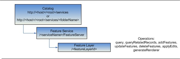
| Supported Operations | Query Query Related Records Add Features Update Features Delete Features Apply Edits Generate Renderer |
| Parent Resource | Feature Service |
| Child Resources | Feature |
Description
The layer resource represents a single editable feature layer or non spatial table in a feature service.
For tables, it provides basic information about the table such as its id, name, fields, relationships with other tables or feature layers, etc.
For feature layers, in addition to the table information above, it provides information such as its geometry type, min and max scales, spatial reference, etc.
Both tables and feature layers publish one or more editable sub-types. This resource includes information about these types as well.
Each type includes information about the type such as the type id, name, definition expression, etc. Feature Layer sub-types also include a default symbol and a list of feature templates.
Each feature template includes a template name, description and a prototypical feature.
If a layer supports querying based on time,
the response includes a timeInfo property. This gives information such as
the start time field (or the time instance field), the end time field, the track ID field,
the layer's time extent, and the suggested draw time interval.
If a layer has attachments, its hasAttachments property will be true.
New in 10.1 SP1
If ownership-based access control is enabled on features, ownershipBasedAccessControlForFeatures property of a layer will include an allowOthersToQuery property.
Prototype templates will not include read only fields such as the editor tracking fields.
New in 10.1
Layer resource supports a new parameter - returnUpdates that accepts a boolean value. Pass this parameter to retrieve updated timeExtent for the layer.
If a layer draws by default when you add the feature service to ArcMap, defaultVisibility will be true.
If a layer has editor tracking enabled, its editFieldsInfo property will be include information about editor tracking fields: creationDateField, creatorField, editDateField, editorField and realm.
If ownership-based access control is enabled on features, ownershipBasedAccessControlForFeatures property of a layer will include allowOthersToUpdate, allowOthersToDelete and allowOthersToQuery properties.
The property supportsRollbackOnFailureParameter will be true if the layer supports setting the rollbackOnFailure parameter for edit operations. For example, apply edits, add features, update features, and delete features.
The property syncCanReturnChanges will be true if the data is versioned and has gloablIds on the server to indicate the support for two way replica which can return changes only.
The property isDataVersioned will be true if the layer is versioned.
The property maxRecordCount returns the maximum number of records that will be returned at once for a query.
The property capabilities now returns additional Create, Delete, Update and Uploads capabilities. Uploads capabilities will be included if Create, Delete or Update is enabled for a Feature Service. Editing capability will be included if Create, Delete or Update is enabled.
The property supportsStatistics indicates if the layer supports statistical functions in query operations and supportsAdvancedQueries indicates if the layer supports orderBy in a query operation.
The property supportedQueryFormats returns the formats in which query results can be returned.
The property hasZ returns true if the features in the layer have Z values.
The property hasM returns true if the features in the layer have M values.
The property allowGeometryUpdates returns true if the geometry of the features in the layer can be edited.
Layer resource returns relatedTableId, cardinality, role, keyField, composite, and keyFieldInRelatedTable properties for relationships. The keyFieldInRelatedTable is returned for attributed relationships only.
Layer resource now returns two new properties: effectiveMinScale and effectiveMaxScale. Effective minimum and maximum scale are calculated based on the minScale and maxScale values of the current layer and its ancestors. These represent the effective minimum and maximum scales at which the layer is visible.
The properties zDefault and enableZDefaults are returned for a service configured with default Z values.
The field property nullable indicates if the field can accept null values.
Resource Hierarchy
Parameters
| Parameter | Details |
|---|---|
| f | Description: The
response format. The default response format is html. Values: html | json |
| returnUpdates |
//This option was added at 10.1 Description: If value is true then returns updated time extent. If the layer is not time-aware then returns an empty response. Values: true | false |
Example Usage
Example 1: Get information about layer 0 in "311Incidents" Feature Service on sampleserver3.
http://sampleserver3.arcgisonline.com/ArcGIS/rest/services/SanFrancisco/311Incidents/FeatureServer/0?f=pjsonJSON Response Syntax
{
"currentVersion": <currentVersion>, //Added at 10.0 SP1
//properties applicable to both feature layers and tables
"id" : <layerOrTableId>,
"name" : "<layerOrTableName>",
"type" : "<layerOrTableType>", //"Feature Layer" or "Table"
"description" : "<description>",
"copyrightText" : "<copyrightText>",
"defaultVisibility": <true | false>,//Added at 10.1
//Added at 10.1
 "editFieldsInfo": {
   "creationDateField": "<creationDateField>",
   "creatorField": "<creatorField>",
   "editDateField": "<editDateField>",
   "editorField": "<editorField>",
   "realm":"<realm>"
 },
 //Added at 10.1
 "ownershipBasedAccessControlForFeatures": {
  "allowOthersToUpdate": <true | false>,
  "allowOthersToDelete": <true | false>,
	"allowOthersToQuery": <true | false>
 },
 //Added at 10.1
 "syncCanReturnChanges": <true | false>,
 "relationships" : [
  {
    "id" : <relationshipId1>,
    "name" : "<relationshipName1>",
    "relatedTableId" : <relatedTableId1>,
    "role" : "<esriRelRoleOrigin>|<esriRelRoleDestination>";,//Added at 10.1
    "cardinality" : "<esriRelCardinalityOneToOne>|<esriRelCardinalityOneToMany>|<esriRelCardinalityManyToMany>";,//Added at 10.1
    "keyField" : "<keyFieldName1>",//Added at 10.1
    "composite" : <true>|<false>,//Added at 10.1
    "relatedTableId": <attributedRelationshipClassTableId>,  //Added in 10.1. Returned only for attributed relationships
    "keyFieldInRelatedTable": "<key field in AttributedRelationshipClass table that matches keyField>" //Added in 10.1. Returned only for attributed relationships
  },
  {
    "id" : <relationshipId2>,
    "name" : "<relationshipName2>",
    "relatedTableId" : <relatedTableId2>,
    "role" : "<esriRelRoleOrigin>|<esriRelRoleDestination>";,//Added at 10.1
    "cardinality" : "<esriRelCardinalityOneToOne>|<esriRelCardinalityOneToMany>|<esriRelCardinalityManyToMany>";,//Added at 10.1
    "keyField" : "<keyFieldName2>",//Added at 10.1
    "composite" : <true>|<false>,//Added at 10.1
    "relatedTableId": <attributedRelationshipClassTableId>,  //Added in 10.1. Returned only for attributed relationships
    "keyFieldInRelatedTable": "<key field in AttributedRelationshipClass table that matches keyField>" //Added in 10.1. Returned only for attributed relationships
  }
],
"isDataVersioned": <true | false>, //Added at 10.1
"supportsRollbackOnFailureParameter": <true | false>, //Added at 10.1
"supportsStatistics": <true | false>, //Added at 10.1
"supportsAdvancedQueries":<true | false>, //Added at 10.1
//properties applicable to feature layers only
"geometryType" : "<geometryType>",
"minScale" : <minScale>,
"maxScale" : <maxScale>,
"effectiveMinScale" : <effectiveMinScale>,
"effectiveMaxScale" : <effectiveMaxScale>,
"extent" :  <envelope>,

//for feature layers only
"drawingInfo" : {
  "renderer" : <renderer>,
  "transparency" : <transparency>,
  "labelingInfo" : <labelingInfo>
},
 "hasM":  <true | false>, //if the features in the layer have M values, the hasM property will be true
 "hasZ":  <true | false>, //if the features in the layer have Z values, the hasZ property will be true
//if the layer / table supports querying based on time
 "enableZDefaults": <true | false>,//Added at 10.1
 "zDefault": <zDefaultValue>,//Added at 10.1
 "allowGeometryUpdates": <true | false>,//Added at 10.1
"timeInfo" : {
  "startTimeField" : "<startTimeFieldName>",
  "endTimeField" : "<endTimeFieldName>",
  "trackIdField" : "<trackIdFieldName>",
  "timeExtent" : [<startTime>, <endTime>],
  "timeReference" : {
    "timeZone" : "<timeZone>",
    "respectsDaylightSaving" : <true | false>
  },
  "timeInterval" : <timeInterval>,
  "timeIntervalUnits" : "<timeIntervalUnits>"
},

//if the layer / table has attachments, the hasAttachments property will be true
"hasAttachments" : <true | false>

//from 10 onward - indicates whether the layer / table has htmlPopups
"htmlPopupType" : "<esriServerHTMLPopupTypeNone | esriServerHTMLPopupTypeAsURL | esriServerHTMLPopupTypeAsHTMLText>",

//layer / table fields
"objectIdField" : "<objectIdFieldName>",
"globalIdField" : "<globalIdFieldName>",
"displayField" : "<displayField>",
"typeIdField" : "<typeIFieldName>",
//from 10.0 fields of type (String, Date, GlobalID, GUID and XML) have an additional length property, editable properties
//from 10.1 fields have an additional nullable property
"fields" : [
  {"name" : "<fieldName1>", "type" : "<fieldType1>", "alias" : "<fieldAlias1>", "length" : "<length1>", "editable" : "<true | false>","nullable" : "<true | false>","domain" : <domain1>},
  {"name" : "<fieldName2>", "type" : "<fieldType2>", "alias" : "<fieldAlias1>", "length" : "<length2>", "editable" : "<true | false>","nullable" : "<true | false>", "domain" : <domain2>}
],
//layer / table sub-types
"types" : [
  {
    "id" : <typeId1>,
    "name" : "<typeName1>",
    "domains" : {
      "<domainField11>" : <domain11>,
      "<domainField12>" : <domain12>
    },
    "templates" : [
      {
        "name" : "<templateName11>",
        "description" : "<templateDescription11>",
        "prototype" : <prototypicalFeature11>
      },
      {
        "name" : "<templateName12>",
        "description" : "<templateDescription12>",
        "prototype" : <prototypicalFeature12>
      }
    ]
  },
  {
    "id" : <typeId2>,
    "name" : "<typeName2>",
    "domains" : {
      "<domainField11>" : <domain21>,
      "<domainField12>" : <domain22>
    },
    "templates" : [
      {
        "name" : "<templateName21>",
        "description" : "<templateDescription21>",
        "prototype" : <prototypicalFeature21>,
        "drawingTool": "esriFeatureEditToolNone | esriFeatureEditToolPoint | esriFeatureEditToolLine | esriFeatureEditToolPolygon |
                        esriFeatureEditToolAutoCompletePolygon | esriFeatureEditToolCircle | esriFeatureEditToolEllipse | esriFeatureEditToolRectangle |
                        esriFeatureEditToolFreehand"
      },
      {
        "name" : "<templateName22>",
        "description" : "<templateDescription22>",
        "prototype" : <prototypicalFeature22>,
        "drawingTool": "esriFeatureEditToolNone | esriFeatureEditToolPoint | esriFeatureEditToolLine | esriFeatureEditToolPolygon |
                        esriFeatureEditToolAutoCompletePolygon | esriFeatureEditToolCircle | esriFeatureEditToolEllipse | esriFeatureEditToolRectangle |
                        esriFeatureEditToolFreehand"
      }
    ]
  }
],

//layer / table templates - usually present when the layer / table has no sub-types
"templates" : [
  {
    "name" : "<templateName1>",
    "description" : "<templateDescription1>",
    "prototype" : <prototypicalFeature1>
  },
  {
    "name" : "<templateName2>",
    "description" : "<templateDescription2>",
    "prototype" : <prototypicalFeature2>
  }
],
//Maximum number of records returned in a query result
"maxRecordCount": <maxRecordCount> //Added at 10.1
"supportedQueryFormats": "<supportedQueryFormats>", //Added at 10.1
//comma separated list of supported capabilities - e.g. "Create,Delete,Query,Update,Editing". Create, Delete and Update capabilities were added at 10.1
"capabilities" : "<capabilities>"

}
JSON Response Example
{
"currentVersion": 10.1,
"id" : 0,
"name" : "Incidents",
"type" : "Feature Layer",
"displayField" : "req_id",
"description" : "",
"copyrightText" : "",
"defaultVisibility": true,
"editFieldsInfo": {
"creationDateField": "DateCreated",
"creatorField": "CreationUser",
"editDateField": "DateModified",
"editorField": "LastUser"
},
"ownershipBasedAccessControlForFeatures": {
"allowUpdateToOthers": false,
"allowDeleteToOthers": false
},
"syncCanReturnChanges": true,
"relationships" : [
{
"id" : 1,
"name" : "ServiceRequest_IncidentPriority",
"relatedTableId" : 1
}
],
"isDataVersioned": false,
"supportsRollbackOnFailureParameter": true,
"geometryType" : "esriGeometryPoint",
"minScale" : 0,
"maxScale" : 0,
"extent" : {
"xmin" : -122.514435102,
"ymin" : 5.6843418860808E-14,
"xmax" : 138.625776397,
"ymax" : 67.1577965990001,
"spatialReference" : {
"wkid" : 4326
}
},
"drawingInfo" : {"renderer" :
{
"type" : "uniqueValue",
"field1" : "req_type",
"field2" : null,
"field3" : null,
"fieldDelimiter" : ", ",
"defaultSymbol" : null,
"defaultLabel" : "\u003call other values\u003e",
"uniqueValueInfos" : [
{
"value" : "Blocked Street or Sidewalk",
"label" : "Blocked Street or Sidewalk",
"description" : "",
"symbol" :
{
"type" : "esriPMS",
"url" : "1DD4FC53",
"imageData" : "iVBORw0KGgoAAAANSUhEUgAAABoAAAAaCAYAAACpSkzOAAAAAXNSR0IB2cksfwAAAAlwSFlzAAAOxAAADsQBlSsOGwAAAsVJREFUSInt001IVFEUwPH/a2bewwyCCZEZMI2gBoRKSdtEROBKooyiDwqt8QNpYQmjYuIHDZGOVDM5RJAwUvRBizYFLmrXoo+F0iKklROkSOQmyrnqvNNinLHRmdcY5Kqzuvfde8/vnnN5dtYp7P+hlbFnp0uq9isCw7PaP4Oqq1zy/PY0KGDRKYGR7NhfQ2mIgoGGWSq3O+VEd2bsT5AYGChU2uHqKpcUbJpG80CkB2qrwFQGx/b+4EmnU05eW41ZQTIz85XCwoKMlWgeSK6fO2AkKpuHmt3w+LJLTt2cTsMsK6qpOYJhGCilAPA1OmWgdaldgGmaicESElf5yDwcLYVHTS45fXcZywqJCObDLchCPqZyiqNxKrW2EHKjBiBUv5Xz3nqYv59CRBlIDDpG9bR8lhVtOPON+B03xED1uzHaE5hs3oX5+QO+F4rGJgfPXsPh3cuIJ6ATjUZzap0kB7bmKeLX3cg8zHWVkOefRK8dZa6rBACHXef4oCJ2z5kVsaxI9boxehMV6B1TxDrdSAzUAx/G2QB5/knqvlxAz0u0yArJCpU6DUwFP1tK2BicBMD8rsMCLLx6inE2AMC2bdsJBm9Qd96LJ/AyK5IVevbmI83XrjISiWiENCkuLiYajS5viKTnKyoqskSyQWKacUYikdQHb0MT3V2dABogExOf8Hh2pOYOXYfEu66tolAo+PtUc9hsAtDX55eeni7iS/9PX59fABw2m1Ux2aFweIhweCh5SwA6OtoA6O6+kkRS+212x9ohEcm0Ly3Gx8fT5m2+Vm4Fw1xquZg7lEuUlZXB8nsIgK4blmdWQjI2Nk55eVoiAIaHR8TrreXgwUMrc2iA6Lo9ieb2Hy3GM7fO663VABkIDFJZUb4Kq/fWZTyXEervDyAST95yVbx9995yPWeovd1nmWBfZcWagYzQv4x1g34BI70ZygdCoCgAAAAASUVORK5CYII=",
"contentType" : "image/png",
"color" : null,
"width" : 19,
"height" : 19,
"angle" : 0,
"xoffset" : 0,
"yoffset" : 0
}
},
{
"value" : "Damaged Property",
"label" : "Damaged Property",
"description" : "",
"symbol" :
{
"type" : "esriPMS",
"url" : "DF3100A6",
"imageData" : "iVBORw0KGgoAAAANSUhEUgAAABQAAAAMCAYAAABiDJ37AAAAAXNSR0IB2cksfwAAAAlwSFlzAAAOxAAADsQBlSsOGwAAAY1JREFUKJGl0j+Iz2EYAPDPw+lJZ+CY/B2kbCKkDEZMN8hoMBoMFmVSSqKUWIyXSThlQAZ/LgMZZFNncUhRvq6L8nTyGu6H3P3uDJ56h+d9n/fzvs/bO+A/ozGICr7DwKzFDTI34YfBwc+6biLoZtUslrlT1WpsbqyLzOuq7s8BZW5UdR6vVB3AWGNT41Zkjqra0tgWVUvxSOZYVI1H1cdfxF9gVD1oLMfalnlK1apgT3BE1X68DUZwI5hSNecJBubMkI1xDATvMY0lLfNaVB3v5Q8x1e9Nf4NtaGiHrnuJp8Gh3umfcFLmYVXLeqXf8LixO5joCzYWta9fDwa7Gq+DN1hppv1hVcPB3cZIsAJrsN28YObpqNraGA9GW+Y7VctlTqsaDJ7IHI6qC1jSuBLcnrflqDqLfYu4Cq3qOZ6pWo8vOKNqFBeDU/2gv0Em9bBe/qENDQ3rupst81ZUnWjckbm0VR0NLi0I9ovouheNc1F1EpPBsah63zL39vsu/wR7N71sZvyZq7q30J6fOkKkEEs/eqsAAAAASUVORK5CYII=",
"contentType" : "image/png",
"color" : null,
"width" : 15,
"height" : 9,
"angle" : 0,
"xoffset" : 0,
"yoffset" : 0
}
},
{
"value" : "Graffiti Complaint - Public Property",
"label" : "Graffiti Complaint",
"description" : "",
"symbol" :
{
"type" : "esriPMS",
"url" : "B2E6E7A0",
"imageData" : "iVBORw0KGgoAAAANSUhEUgAAABoAAAAaCAYAAACpSkzOAAAAAXNSR0IB2cksfwAAAAlwSFlzAAAOxAAADsQBlSsOGwAAAiVJREFUSInt1EFIVFEUxvH/4DgnmUR8MTpjUJQPImgTIQbWoqCFixSEgoTaJFJZibawjNJCkiQIF5GImxaGGGIiZFiEBSa1ikLIGpLpWUNGb8J8OWfMsUVGFGZag5D4re4958KPe+BeN4sU99KFdovkpUBFu2rlTkjLEGmYUO/LLuzjCYW6VfuBF4Dcg2eo5teu9Wd3hexEOD+Nbn2jafLUtms+Oo5vDO4OhkK3ikX6Jg2jKVM14w1s6bTtWmD4r6EKwzj6yLLWxWHqs/qvFpjJqwYsq6hVdceZcNiogw9NhpGTZRjbr9j2MOACphcMXbbtSoA74OkjlHksiFUiUlMgcrEXbqL6eMBxzo9DFLhdLnJgBLY9VD0ZhufzhopFuiYhvkv1EGABvPJ6R9c4Tvp+r7esRdW6pppfDys6INqoeqnZNDsiwaAdXsiNrqsW/tos9Pkin0T871XH9gQCeTfC4bZTEC0RuRCBzaXB4MFSkRPpsHUEarMgr1O1FXj7W2i2lA8Ntc1Wb1GtroGUDphoVj1bBoHVIvtGoe6wSNoAPHii2jtvaK6cg4mZZWqOaXZmJ0lu9Nv+9N4pihqCg1U90P3P0PdUS6DdnyS5MSBp6gsuIA4bNxlGfY9tJw4Sg/QMdzIA0+5kXDN1Q1IFfjz2hP51rjl6S/j3XoaWof8H8nk89/vtdxtSPZ6VLnBPQzwWi407qq8TCh0JhaqAqj+dW7TRfQVgAs+jjDbsggAAAABJRU5ErkJggg==",
"contentType" : "image/png",
"color" : null,
"width" : 19,
"height" : 19,
"angle" : 0,
"xoffset" : 0,
"yoffset" : 0
}
},
{
"value" : "Graffiti Complaint Private Property",
"label" : "Graffiti Complaint",
"description" : "",
"symbol" :
{
"type" : "esriPMS",
"url" : "B2E6E7A0",
"imageData" : "iVBORw0KGgoAAAANSUhEUgAAABoAAAAaCAYAAACpSkzOAAAAAXNSR0IB2cksfwAAAAlwSFlzAAAOxAAADsQBlSsOGwAAAiVJREFUSInt1EFIVFEUxvH/4DgnmUR8MTpjUJQPImgTIQbWoqCFixSEgoTaJFJZibawjNJCkiQIF5GImxaGGGIiZFiEBSa1ikLIGpLpWUNGb8J8OWfMsUVGFGZag5D4re4958KPe+BeN4sU99KFdovkpUBFu2rlTkjLEGmYUO/LLuzjCYW6VfuBF4Dcg2eo5teu9Wd3hexEOD+Nbn2jafLUtms+Oo5vDO4OhkK3ikX6Jg2jKVM14w1s6bTtWmD4r6EKwzj6yLLWxWHqs/qvFpjJqwYsq6hVdceZcNiogw9NhpGTZRjbr9j2MOACphcMXbbtSoA74OkjlHksiFUiUlMgcrEXbqL6eMBxzo9DFLhdLnJgBLY9VD0ZhufzhopFuiYhvkv1EGABvPJ6R9c4Tvp+r7esRdW6pppfDys6INqoeqnZNDsiwaAdXsiNrqsW/tos9Pkin0T871XH9gQCeTfC4bZTEC0RuRCBzaXB4MFSkRPpsHUEarMgr1O1FXj7W2i2lA8Ntc1Wb1GtroGUDphoVj1bBoHVIvtGoe6wSNoAPHii2jtvaK6cg4mZZWqOaXZmJ0lu9Nv+9N4pihqCg1U90P3P0PdUS6DdnyS5MSBp6gsuIA4bNxlGfY9tJw4Sg/QMdzIA0+5kXDN1Q1IFfjz2hP51rjl6S/j3XoaWof8H8nk89/vtdxtSPZ6VLnBPQzwWi407qq8TCh0JhaqAqj+dW7TRfQVgAs+jjDbsggAAAABJRU5ErkJggg==",
"contentType" : "image/png",
"color" : null,
"width" : 19,
"height" : 19,
"angle" : 0,
"xoffset" : 0,
"yoffset" : 0
}
},
{
"value" : "Sewer Issues",
"label" : "Sewer Issues",
"description" : "",
"symbol" :
{
"type" : "esriPMS",
"url" : "80DC11A7",
"imageData" : "iVBORw0KGgoAAAANSUhEUgAAABYAAAAaCAYAAACzdqxAAAAAAXNSR0IB2cksfwAAAAlwSFlzAAAOxAAADsQBlSsOGwAAA1FJREFUSInd019oU1ccB/DvPefm3vQ2f9qYmMRio/inlYrNnKBzBTtB+hAROiuIIiIoRcWCD/ZFtCg+CI45wQkOh5NtYXNgERldJ6igdK1uEqIRq1Ux1eaP/XfbmzT35ubePQSjkpvN6vbi7+mc3znnw48fv8Pifwr2w4X9gGfttpWrdT23SlZQ/0KU5iaHJZtnpiXpdjjaj567/vPbwsyh1sYTU2klMDg84vmxq18Ine0xulfN8/hp76aPFxwP/nXkX+GO7Y03P633LbMIJshKDrtaGvD1+RsIdvcX3ZVl4MJvdw+3Nq/sPt3Zc6sk/NW+pt3VLvuy2/eG0H7yMgBga6AOOzc0YGQ8g+6+p0Vvno7KjKqmvwdQWxIWx9JtFp8H7SfPF3Lnfo2AEGBnyyeGMAD88Huopg7wRoCYIWyzCTMjj+JF+bOXImhurEfTcp8hLstA06blmyPBvi8MYY5jzYOxMcOqwg+GsGbFwpJVsxQrgBKtUGQ1x5uo4cO7j2NYt2qx4Vk+qL0knMpkJ+oXesuPta2Bs0KArgMmloBhAErJP6AAR5EoCROCh5V2wdvgskHTASWrglIKl70Mqqbj6p+PS8ImjrtgCH/X0bzPX+Pxa5oGMSWD51hUuWxgab41Y6OTCD+IGqIbVs+f7PjmWjF8Zv/6zz+qdR/JyCqnQ4PPU4nJtIzxyQwoYQAA0ZiIMxcjRWidz6EvrZ277ZcrAyiCfbMsB6wCz5lN+bSay0GaUuB2lCMxIiEaH8ep4Ktv3ej3ajXz3BNVTkd/hUD3th2//MfLswL87YHmlmq33S9KGZh5CimdBUsJvDOsCN2Pxbt77wtOuxBf+9miexsDS3tZQrpaj14KXwvFDNtSgD1OISBNySgzm5AcTWG2uwIAkFVz8vOEGDjdGbptKJSIAmwpMy9JTSmotAngORMAYHQiDSWr9uz5smta6BuwiWWqVDW/dlaUQdc1MABSGbV3uugbMBgIDMkPP2EIRCkDazmP8MOh4hGYDqzl9BTHUmthr2mghMGdgaTx0L4tnNM0aIr2ZGBwmJ8/2znLWs4jmhCfhYJ94feCn8XH5eSwuMVmpbqUki8SQhLRoZEdVwDxveDNBzvnvJZ3vQtmCP/X8Td+Qz8dmAROewAAAABJRU5ErkJggg==",
"contentType" : "image/png",
"color" : null,
"width" : 16,
"height" : 19,
"angle" : 0,
"xoffset" : 0,
"yoffset" : 0
}
},
{
"value" : "Sidewalk and Curb Issues",
"label" : "Sidewalk and Curb Issues",
"description" : "",
"symbol" :
{
"type" : "esriPMS",
"url" : "19213DC2",
"imageData" : "iVBORw0KGgoAAAANSUhEUgAAABoAAAAaCAYAAACpSkzOAAAAAXNSR0IB2cksfwAAAAlwSFlzAAAOxAAADsQBlSsOGwAAAllJREFUSIntls1rE0EYh5/aNmldqyV4aCB0WsFDDyr1JthItIe2GvwAD8WWaiy0eFD8J0ohgmgL4sFvJYgoiFj0VIieBEGrFClUutGDYK1i3SS7SToeko0bd5NsDxYF39Mys7PP/Gafndk61qjq/oPWBBT298pJZgEIekBV1Zo/AprxzIKRv75qwL5VjHUNEkLIuAHe1naa93bB9ZsIIaTbVK5B8UKSl69m6Ds9WmwTLse7AgkhJAbMLS3TCExHThF6eJfEiWHXqVyBzDTd6S8l7c39/cRjMYIuYFVBZppPukEr0NbWBsDCwgIbRyJ8i8XY4GKyFUGmAIGzZ1gaj9r6X+/aw465t0xt21k1VUXQSVOA8SjrHfrrgTfdfWyiuhhlQUIIOWRAYHSExQsTOE11HaAnErS+f0eiY3tFMcqCTAGej52jUfEiHe5ZASTwbEs7wttUMZUjyBQgMDDA/MVLZCluCCVlAFkgp4F2uAdl6knZVDZQ2N8rJ41ZapUGZDKVh2g6tYoXyNtmBaU1nQwwf/seBx7fJz543FEMG8jcz/yHjvBg4jINZoemA6V6pzQdA8gAOnBnfw9dvhbGDDhWKVFR5+EI8vsPDDRqUID8+/i90haIgUYW8AwNsvvGLdsSloBMAZAScpIMINHIAfUFoHXp0oBeAGQKbU/PRwn5WmxiOMrw8co1NodCHO07SC6ZQibTyGWNr1s7gRQvPnxmhfx3VItCzjK209dkXaFHqqqGbaCg51eqxelppzkA0GF5WLkqHIxhx0Sqqta43fZXW3/nP8M/AfoJ8vL8uVAvCyMAAAAASUVORK5CYII=",
"contentType" : "image/png",
"color" : null,
"width" : 19,
"height" : 19,
"angle" : 0,
"xoffset" : 0,
"yoffset" : 0
}
},
{
"value" : "Tree Maintenance or Damage",
"label" : "Tree Maintenance or Damage",
"description" : "",
"symbol" :
{
"type" : "esriPMS",
"url" : "37B62A6C",
"imageData" : "iVBORw0KGgoAAAANSUhEUgAAABcAAAAaCAYAAABctMd+AAAAAXNSR0IB2cksfwAAAAlwSFlzAAAOxAAADsQBlSsOGwAAAoRJREFUSInd1l1IU2EYB/D/zsc29fixhYNJSJYyszAiaWAJRshEyl1YUBvksBphQdTFxCRz3QwKCQMJhchdbEURJQWBYogXwYg+LhyUFJqQW5TnKLiPs7Oz080ShZ3ZmXnT/+593uf8eF7OB4fCFob6P3Gj/8De2hWMzWmoxByNR3qR3F8XUx8pU9eeH3Lc9QIgAKQU4XpfQx1LiNUhCc4QA2O63BUigRdMAntSX2/bvc4Tr+iZlipRx+8Tyq3DHQPjG+P++kEWYick+RMFCa40SHDHACBA/sjTQ+MDYMiO+xp2AmKnPJs5r4nvpfYR5yijypsaah/oz4jrCejYLBPLhVeJ8KmnWwG02rzOJn/7cPN63Fd/nZXEHuX0+nD8tKW7+2S+x/Mkuoq3LaHzqQ6azeKF1I4Fj8cfBdZM/lKHYQC9m4HbklWfHnd4d/9Zr+K87U0ffOZ5qMgeABW54BwR3b52vfaGSrAH7sNf78gV16UKFuTwdMR+gDQDoNOFCACtBpg5Ox81RbQgxgwlyRASFACcStSMkSqCpyVq3qgtdmXHbYHn+oeNB1kpcRUSDBqIbh4r33iyZqly9kO4OCwUMscPWTlKuEyDnPU67l2QO0nG1589PfkRwBkA4FerQSQvmiKAUFgej7wbvDRikUOz4rLNKWWPqiJcHRMZAFgUlmW/hDnh5+6gSDsl0BIF3Lry7Oc/xQ3LlVZVSkCsiP6rqRXhVJxpATgktBp+426FeBEXawYAMpmkN+pVhLtdpgnd53gJADC/4tRNt3W898Zo06bxvm7zhDq+WBbexbzPX+arVQBREP5y2ONqZKVtFZZrXQ/e5o57AkfldyezXrulvxa/Abje1Oc+QPwDAAAAAElFTkSuQmCC",
"contentType" : "image/png",
"color" : null,
"width" : 17,
"height" : 19,
"angle" : 0,
"xoffset" : 0,
"yoffset" : 0
}
}
]
},
"transparency" : 0,
"labelingInfo" : null},
"hasM": false,
"hasZ": false,
"timeInfo": {
"startTimeField": "req_date",
"endTimeField": null,
"trackIdField": null,
"timeExtent": [
965325661000,
972216000000
],
"timeReference": {
"timeZone": "Pacific Standard Time",
"respectsDaylightSaving": false
},
"timeInterval": 1,
"timeIntervalUnits": "esriTimeUnitsDays",
"exportOptions": {
"useTime": true,
"timeDataCumulative": false,
"timeOffset": null,
"timeOffsetUnits": null
}
},
"hasAttachments" : true,
"htmlPopupType" : "esriServerHTMLPopupTypeAsHTMLText",
"objectIdField" : "objectid",
"globalIdField" : "",
"typeIdField" : "req_type",
"fields" : [
{
"name" : "objectid",
"type" : "esriFieldTypeOID",
"alias" : "Object ID",
"editable" : false,
"nullable" : true,
"domain" : null
},
{
"name" : "req_id",
"type" : "esriFieldTypeString",
"alias" : "Request ID",
"editable" : true,
"length" : 20,
"nullable" : true,
"domain" : null
},
{
"name" : "req_type",
"type" : "esriFieldTypeString",
"alias" : "Request Type",
"editable" : true,
"length" : 40,
"nullable" : true,
"domain" : null
},
{
"name" : "req_date",
"type" : "esriFieldTypeDate",
"alias" : "Request Date",
"editable" : true,
"length" : 30,
"nullable" : true,
"domain" : null
},
{
"name" : "req_time",
"type" : "esriFieldTypeString",
"alias" : "Request Time",
"editable" : true,
"length" : 20,
"nullable" : true,
"domain" : null
},
{
"name" : "address",
"type" : "esriFieldTypeString",
"alias" : "Address",
"editable" : true,
"length" : 60,
"nullable" : true,
"domain" : null
},
{
"name" : "x_coord",
"type" : "esriFieldTypeString",
"alias" : "X Coordinate",
"editable" : true,
"length" : 20,
"nullable" : true,
"domain" : null
},
{
"name" : "y_coord",
"type" : "esriFieldTypeString",
"alias" : "Y Coordinate",
"editable" : true,
"length" : 20,
"nullable" : true,
"domain" : null
},
{
"name" : "district",
"type" : "esriFieldTypeString",
"alias" : "District",
"editable" : true,
"length" : 20,
"nullable" : true,
"domain" : null
},
{
"name" : "status",
"type" : "esriFieldTypeSmallInteger",
"alias" : "Status",
"editable" : true,
"nullable" : true,
"domain" :
{
"type" : "codedValue",
"name" : "StatusCodes",
"codedValues" : [
{
"name" : "New",
"code" : 1
},
{
"name" : "Open",
"code" : 2
},
{
"name" : "Closed",
"code" : 3
}
]
}
}
],
"types" : [
{
"id" : "Graffiti Complaint Private Property",
"name" : "Graffiti Complaint",
"domains" :
{
},
"templates" : [
{
"name" : "Graffiti Complaint",
"description" : "",
"drawingTool" : "esriFeatureEditToolPoint",
"prototype" : {
"attributes" : {
"status" : 1,
"req_id" : null,
"req_type" : "Graffiti Complaint Private Property",
"req_date" : null,
"req_time" : null,
"address" : null,
"x_coord" : null,
"y_coord" : null,
"district" : null
}
}
}
]
},
{
"id" : "Blocked Street or Sidewalk",
"name" : "Blocked Street or Sidewalk",
"domains" :
{
},
"templates" : [
{
"name" : "Blocked Street or Sidewalk",
"description" : "",
"drawingTool" : "esriFeatureEditToolPoint",
"prototype" : {
"attributes" : {
"status" : 1,
"req_id" : null,
"req_type" : "Blocked Street or Sidewalk",
"req_date" : null,
"req_time" : null,
"address" : null,
"x_coord" : null,
"y_coord" : null,
"district" : null
}
}
}
]
},
{
"id" : "Damaged Property",
"name" : "Damaged Property",
"domains" :
{
},
"templates" : [
{
"name" : "Damaged Property",
"description" : "",
"drawingTool" : "esriFeatureEditToolPoint",
"prototype" : {
"attributes" : {
"status" : 1,
"req_id" : null,
"req_type" : "Damaged Property",
"req_date" : null,
"req_time" : null,
"address" : null,
"x_coord" : null,
"y_coord" : null,
"district" : null
}
}
}
]
},
{
"id" : "Graffiti Complaint - Public Property",
"name" : "Graffiti Complaint",
"domains" :
{
},
"templates" : [
{
"name" : "Graffiti Complaint",
"description" : "",
"drawingTool" : "esriFeatureEditToolPoint",
"prototype" : {
"attributes" : {
"status" : 1,
"req_id" : null,
"req_type" : "Graffiti Complaint - Public Property",
"req_date" : null,
"req_time" : null,
"address" : null,
"x_coord" : null,
"y_coord" : null,
"district" : null
}
}
}
]
},
{
"id" : "Sewer Issues",
"name" : "Sewer Issues",
"domains" :
{
},
"templates" : [
{
"name" : "Sewer Issues",
"description" : "",
"drawingTool" : "esriFeatureEditToolPoint",
"prototype" : {
"attributes" : {
"status" : 1,
"req_id" : null,
"req_type" : "Sewer Issues",
"req_date" : null,
"req_time" : null,
"address" : null,
"x_coord" : null,
"y_coord" : null,
"district" : null
}
}
}
]
},
{
"id" : "Tree Maintenance or Damage",
"name" : "Tree Maintenance or Damage",
"domains" :
{
},
"templates" : [
{
"name" : "Tree Maintenance or Damage",
"description" : "",
"drawingTool" : "esriFeatureEditToolPoint",
"prototype" : {
"attributes" : {
"status" : 1,
"req_id" : null,
"req_type" : "Tree Maintenance or Damage",
"req_date" : null,
"req_time" : null,
"address" : null,
"x_coord" : null,
"y_coord" : null,
"district" : null
}
}
}
]
},
{
"id" : "Sidewalk and Curb Issues",
"name" : "Sidewalk and Curb Issues",
"domains" :
{
},
"templates" : [
{
"name" : "Sidewalk and Curb Issues",
"description" : "",
"drawingTool" : "esriFeatureEditToolPoint",
"prototype" : {
"attributes" : {
"status" : 1,
"req_id" : null,
"req_type" : "Sidewalk and Curb Issues",
"req_date" : null,
"req_time" : null,
"address" : null,
"x_coord" : null,
"y_coord" : null,
"district" : null
}
}
}
]
}
],
"templates" : [
],
"maxRecordCount": 1000,
"supportedQueryFormats": "JSON, AMF",
"capabilities" : "Create,Delete,Query,Update,Editing"
}